Takahagi geodata
Takahagi (Ibaraki) is a seat of a second-order administrative division; located in Japan in Asia/Tokyo (GMT+9) time zone. With population of 33,576 people, there are 509 cities with bigger population in this country. Compared to other cities in Japan, 79.9% of cities are located further ↓South; 90.2% of cities are located further ←West and 86% of cities have higher elevation than Takahagi. Note1


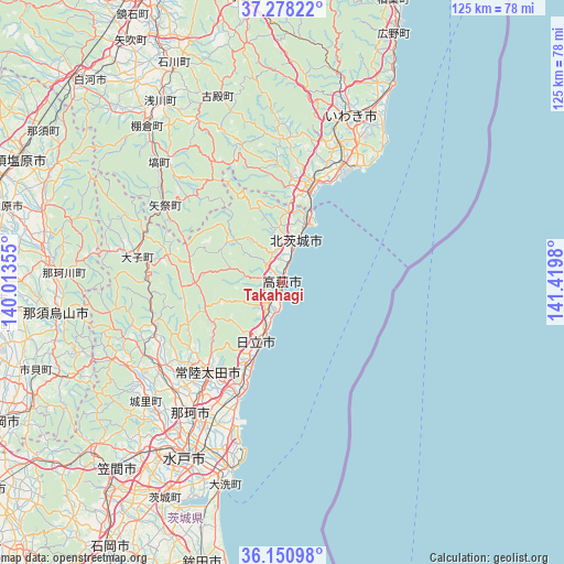
Takahagi GPS coordinates[2]
36° 43' 0.012" North, 140° 43' 0.012" East
| Map corner | latitude | longitude |
|---|---|---|
| Upper-left | 37.27822°, | 140.01355° |
| Center: | 36.71667°, | 140.71667° |
| Lower-right: | 36.15098°, | 141.4198° |
| Map W x H: | 125.3×125.3 km | = 77.9×77.9mi |
| max Lat: | 45.40944° ⇑20.1% North |
| Takahagi: | 36.71667° |
| min Lat: | ⇓79.9% South 24.34478° |
| min Long | Takahagi | max Long |
| 123° | 140.71667° | 145.575° |
| W 90.2%⇐ | ⇒9.8% E |
Elevation
Elevation of Takahagi is 6 m = 20 ft, and this is 78.6 m = 258 ft below average elevation for this country.
| Max E: |
1086 m = 3563 ft | 86% |
| Avg. | 84.6 m = 278 ft | |
| Takahagi | 6 m = 20 ft | |
Min E: |
-2 m = -7 ft | 14% |
See also: Japan elevation on elevation.city.
Geographical zone
Takahagi is located in North temperate zone (between Tropic of Cancer and the Arctic Circle). Distance of this Northern Tropic circle is 1476.6 km =917.5 mi to South.| Distance of | km | miles | from Takahagi |
|---|---|---|---|
| North Pole | 5924.6 | 3681.4 | to North |
| Arctic Circle | 3318.7 | 2062.1 | to North |
| Tropic Cancer | 1476.6 | 917.5 | to South |
| Equator | 4082.5 | 2536.7 | to South |


Nearby cities:
15 places around Takahagi: (largest is in red/bold)
• Daigo
33.1 km =20.6 mi,  279°
279°
• Funaishikawa
30.9 km =19.2 mi,  205°
205°
• Hitachi
14.3 km =8.9 mi,  204°
204°
• Hitachi-Naka
39.1 km =24.3 mi, 204°
• Hitachi-ota
24.9 km =15.5 mi,  222°
222°
• Hitachiomiya
32.7 km =20.3 mi,  238°
238°
• Iwaki
39.9 km =24.8 mi,  21°
21°
• Karasuyama
51.1 km =31.8 mi,  261°
261°
• Katsuta
40.5 km =25.2 mi, 203°
• Kitaibaraki
8.3 km =5.2 mi, 20°
• Mito
47.2 km =29.3 mi, 210°
• Motegi
52.5 km =32.6 mi, 244°
• Nasukarasuyama
50.1 km =31.1 mi, 261°
• Ōarai
46.3 km =28.8 mi,  194°
194°
• Ōmiya
32.6 km =20.3 mi, 235°
Sources, notices
• [Note1] Compared only with cities in Japan existing in our database
• [Src1] Map data: © OpenStreetMap contributors (CC-BY-SA)
• [Src2] Other city data from geonames.org with taken over terms of usage.
• [Src3] Geographical zone / Annual Mean Temperature by Robert A. Rohde @ Wikipedia
