Katsuta geodata
Katsuta (Ibaraki) is a populated place; located in Japan in Asia/Tokyo (GMT+9) time zone. With population of 155,968 people, there are 134 cities with bigger population in this country. Compared to other cities in Japan, 75.3% of cities are located further ↓South; 87.6% of cities are located further ←West and 57.5% of cities have higher elevation than Katsuta. Note1


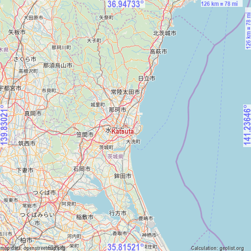
Katsuta GPS coordinates[2]
36° 22' 59.988" North, 140° 31' 59.988" East
| Map corner | latitude | longitude |
|---|---|---|
| Upper-left | 36.94733°, | 139.83021° |
| Center: | 36.38333°, | 140.53333° |
| Lower-right: | 35.81521°, | 141.23646° |
| Map W x H: | 125.9×125.9 km | = 78.2×78.2mi |
| max Lat: | 45.40944° ⇑24.7% North |
| Katsuta: | 36.38333° |
| min Lat: | ⇓75.3% South 24.34478° |
| min Long | Katsuta | max Long |
| 123° | 140.53333° | 145.575° |
| W 87.6%⇐ | ⇒12.4% E |
Elevation
Elevation of Katsuta is 21 m = 69 ft, and this is 63.6 m = 209 ft below average elevation for this country.
| Max E: |
1086 m = 3563 ft | 57.5% |
| Avg. | 84.6 m = 278 ft | |
| Katsuta | 21 m = 69 ft | |
Min E: |
-2 m = -7 ft | 42.5% |
See also: Katsuta elevation on elevation.city.
Geographical zone
Katsuta is located in North temperate zone (between Tropic of Cancer and the Arctic Circle). Distance of this Northern Tropic circle is 1439.5 km =894.5 mi to South.| Distance of | km | miles | from Katsuta |
|---|---|---|---|
| North Pole | 5961.6 | 3704.4 | to North |
| Arctic Circle | 3355.7 | 2085.1 | to North |
| Tropic Cancer | 1439.5 | 894.5 | to South |
| Equator | 4045.4 | 2513.7 | to South |


Nearby cities:
15 places around Katsuta: (largest is in red/bold)
• Funaishikawa
9.7 km =6 mi,  17°
17°
• Hitachi
26.3 km =16.3 mi, 23°
• Hitachi-Naka
1.5 km =0.9 mi,  5°
5°
• Hitachi-ota
18.7 km =11.6 mi,  358°
358°
• Hitachiomiya
23.3 km =14.5 mi,  329°
329°
• Hokota
26 km =16.2 mi,  183°
183°
• Ishioka
32.6 km =20.3 mi,  227°
227°
• Kasama
23.9 km =14.9 mi,  270°
270°
• Mito
8.3 km =5.2 mi,  243°
243°
• Motegi
34.6 km =21.5 mi,  295°
295°
• Okunoya
15.3 km =9.5 mi,  223°
223°
• Omitama
19.9 km =12.4 mi, 223°
• Tomobe
21.2 km =13.2 mi,  259°
259°
• Ōarai
8.9 km =5.5 mi,  149°
149°
• Ōmiya
21.3 km =13.2 mi, 330°
Sources, notices
• [Note1] Compared only with cities in Japan existing in our database
• [Src1] Map data: © OpenStreetMap contributors (CC-BY-SA)
• [Src2] Other city data from geonames.org with taken over terms of usage.
• [Src3] Geographical zone / Annual Mean Temperature by Robert A. Rohde @ Wikipedia
