Ōmiya geodata
Ōmiya (Ibaraki) is a populated place; located in Japan in Asia/Tokyo (GMT+9) time zone. With population of 27,588 people, there are 572 cities with bigger population in this country. Compared to other cities in Japan, 77.8% of cities are located further ↓South; 85.7% of cities are located further ←West and 64.2% of cities have lower elevation than Ōmiya. Note1


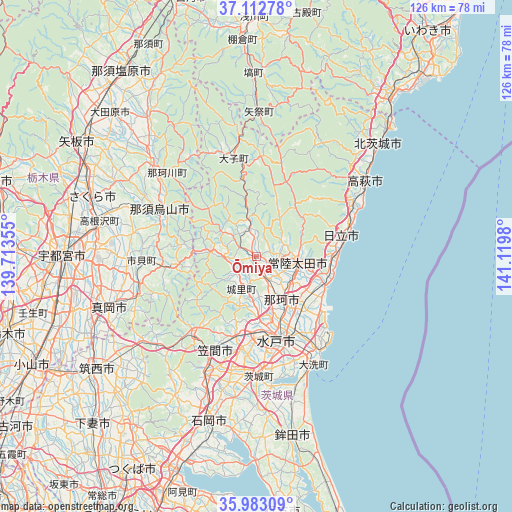
Ōmiya GPS coordinates[2]
36° 33' 0" North, 140° 25' 0.012" East
| Map corner | latitude | longitude |
|---|---|---|
| Upper-left | 37.11278°, | 139.71355° |
| Center: | 36.55°, | 140.41667° |
| Lower-right: | 35.98309°, | 141.1198° |
| Map W x H: | 125.6×125.6 km | = 78×78mi |
| max Lat: | 45.40944° ⇑22.2% North |
| Ōmiya: | 36.55° |
| min Lat: | ⇓77.8% South 24.34478° |
| min Long | Ōmiya | max Long |
| 123° | 140.41667° | 145.575° |
| W 85.7%⇐ | ⇒14.3% E |
Elevation
Elevation of Ōmiya is 56 m = 184 ft, and this is 28.6 m = 94 ft below average elevation for this country.
| Max E: |
1086 m = 3563 ft | 35.8% |
| Avg. | 84.6 m = 278 ft | |
| Ōmiya | 56 m = 184 ft | |
Min E: |
-2 m = -7 ft | 64.2% |
See also: Japan elevation on elevation.city.
Geographical zone
Ōmiya is located in North temperate zone (between Tropic of Cancer and the Arctic Circle). Distance of this Northern Tropic circle is 1458.1 km =906 mi to South.| Distance of | km | miles | from Ōmiya |
|---|---|---|---|
| North Pole | 5943.1 | 3692.9 | to North |
| Arctic Circle | 3337.2 | 2073.6 | to North |
| Tropic Cancer | 1458.1 | 906 | to South |
| Equator | 4064 | 2525.3 | to South |


Nearby cities:
15 places around Ōmiya: (largest is in red/bold)
• Daigo
24.8 km =15.4 mi,  346°
346°
• Funaishikawa
16.3 km =10.1 mi,  124°
124°
• Hitachi
21.6 km =13.4 mi,  75°
75°
• Hitachi-Naka
20.1 km =12.5 mi,  148°
148°
• Hitachi-ota
10 km =6.2 mi,  89°
89°
• Hitachiomiya
2 km =1.2 mi,  322°
322°
• Karasuyama
26.3 km =16.3 mi,  295°
295°
• Kasama
22.9 km =14.2 mi,  215°
215°
• Katsuta
21.3 km =13.2 mi, 150°
• Mashiko
29.8 km =18.5 mi,  251°
251°
• Mito
22.4 km =13.9 mi,  172°
172°
• Motegi
21.2 km =13.2 mi,  259°
259°
• Nasukarasuyama
25.5 km =15.8 mi, 296°
• Okunoya
29.7 km =18.5 mi,  180°
180°
• Tomobe
24.6 km =15.3 mi,  205°
205°
Sources, notices
• [Note1] Compared only with cities in Japan existing in our database
• [Src1] Map data: © OpenStreetMap contributors (CC-BY-SA)
• [Src2] Other city data from geonames.org with taken over terms of usage.
• [Src3] Geographical zone / Annual Mean Temperature by Robert A. Rohde @ Wikipedia
