Mito geodata
Mito (Ibaraki) is a seat of a first-order administrative division; located in Japan in Asia/Tokyo (GMT+9) time zone. With population of 246,538 people, there are 82 cities with bigger population in this country. Compared to other cities in Japan, 74.9% of cities are located further ↓South; 86.2% of cities are located further ←West and 50.1% of cities have higher elevation than Mito. Note1


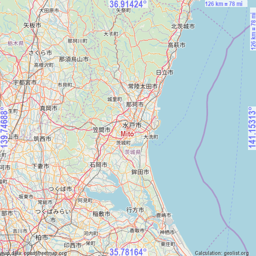
Mito GPS coordinates[2]
36° 21' 0" North, 140° 27' 0" East
| Map corner | latitude | longitude |
|---|---|---|
| Upper-left | 36.91424°, | 139.74688° |
| Center: | 36.35°, | 140.45° |
| Lower-right: | 35.78164°, | 141.15313° |
| Map W x H: | 125.9×125.9 km | = 78.2×78.2mi |
| max Lat: | 45.40944° ⇑25.1% North |
| Mito: | 36.35° |
| min Lat: | ⇓74.9% South 24.34478° |
| min Long | Mito | max Long |
| 123° | 140.45° | 145.575° |
| W 86.2%⇐ | ⇒13.8% E |
Elevation
Elevation of Mito is 28 m = 92 ft, and this is 56.6 m = 186 ft below average elevation for this country.
| Max E: |
1086 m = 3563 ft | 50.1% |
| Avg. | 84.6 m = 278 ft | |
| Mito | 28 m = 92 ft | |
Min E: |
-2 m = -7 ft | 49.9% |
See also: Mito elevation on elevation.city.
Geographical zone
Mito is located in North temperate zone (between Tropic of Cancer and the Arctic Circle). Distance of this Northern Tropic circle is 1435.8 km =892.2 mi to South.| Distance of | km | miles | from Mito |
|---|---|---|---|
| North Pole | 5965.3 | 3706.7 | to North |
| Arctic Circle | 3359.4 | 2087.4 | to North |
| Tropic Cancer | 1435.8 | 892.2 | to South |
| Equator | 4041.7 | 2511.4 | to South |


Nearby cities:
15 places around Mito: (largest is in red/bold)
• Funaishikawa
16.7 km =10.4 mi,  38°
38°
• Hitachi-Naka
9.2 km =5.7 mi,  55°
55°
• Hitachi-ota
23.5 km =14.6 mi,  17°
17°
• Hitachiomiya
24.2 km =15 mi,  349°
349°
• Hokota
23 km =14.3 mi,  164°
164°
• Ishioka
24.8 km =15.4 mi,  221°
221°
• Kasama
16.8 km =10.4 mi,  282°
282°
• Kasumigaura
28.5 km =17.7 mi, 219°
• Katsuta
8.3 km =5.2 mi, 63°
• Motegi
30.2 km =18.8 mi,  307°
307°
• Okunoya
8 km =5 mi,  201°
201°
• Omitama
12.4 km =7.7 mi,  210°
210°
• Tomobe
13.4 km =8.3 mi,  270°
270°
• Ōarai
12.6 km =7.8 mi,  108°
108°
• Ōmiya
22.4 km =13.9 mi, 352°
Sources, notices
• [Note1] Compared only with cities in Japan existing in our database
• [Src1] Map data: © OpenStreetMap contributors (CC-BY-SA)
• [Src2] Other city data from geonames.org with taken over terms of usage.
• [Src3] Geographical zone / Annual Mean Temperature by Robert A. Rohde @ Wikipedia
