Funaishikawa geodata
Funaishikawa (Ibaraki) is a populated place; located in Japan in Asia/Tokyo (GMT+9) time zone. With population of 35,318 people, there are 495 cities with bigger population in this country. Compared to other cities in Japan, 76.9% of cities are located further ↓South; 88.3% of cities are located further ←West and 53.2% of cities have lower elevation than Funaishikawa. Note1


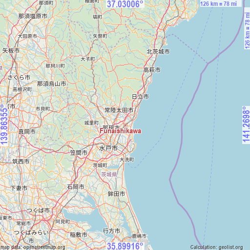
Funaishikawa GPS coordinates[2]
36° 28' 0.012" North, 140° 34' 0.012" East
| Map corner | latitude | longitude |
|---|---|---|
| Upper-left | 37.03006°, | 139.86355° |
| Center: | 36.46667°, | 140.56667° |
| Lower-right: | 35.89916°, | 141.2698° |
| Map W x H: | 125.7×125.7 km | = 78.1×78.1mi |
| max Lat: | 45.40944° ⇑23.1% North |
| Funaishikawa: | 36.46667° |
| min Lat: | ⇓76.9% South 24.34478° |
| min Long | Funaishikawa | max Long |
| 123° | 140.56667° | 145.575° |
| W 88.3%⇐ | ⇒11.7% E |
Elevation
Elevation of Funaishikawa is 32 m = 105 ft, and this is 52.6 m = 173 ft below average elevation for this country.
| Max E: |
1086 m = 3563 ft | 46.8% |
| Avg. | 84.6 m = 278 ft | |
| Funaishikawa | 32 m = 105 ft | |
Min E: |
-2 m = -7 ft | 53.2% |
See also: Japan elevation on elevation.city.
Geographical zone
Funaishikawa is located in North temperate zone (between Tropic of Cancer and the Arctic Circle). Distance of this Northern Tropic circle is 1448.8 km =900.2 mi to South.| Distance of | km | miles | from Funaishikawa |
|---|---|---|---|
| North Pole | 5952.3 | 3698.6 | to North |
| Arctic Circle | 3346.5 | 2079.4 | to North |
| Tropic Cancer | 1448.8 | 900.2 | to South |
| Equator | 4054.7 | 2519.5 | to South |


Nearby cities:
15 places around Funaishikawa: (largest is in red/bold)
• Hitachi
16.6 km =10.3 mi,  26°
26°
• Hitachi-Naka
8.3 km =5.2 mi,  200°
200°
• Hitachi-ota
10 km =6.2 mi,  339°
339°
• Hitachiomiya
18.2 km =11.3 mi,  306°
306°
• Hokota
35.5 km =22.1 mi,  187°
187°
• Kasama
28.4 km =17.6 mi,  250°
250°
• Katsuta
9.7 km =6 mi, 197°
• Mito
16.7 km =10.4 mi,  218°
218°
• Motegi
34.7 km =21.6 mi,  279°
279°
• Okunoya
24.4 km =15.2 mi,  213°
213°
• Omitama
28.9 km =18 mi, 215°
• Takahagi
30.9 km =19.2 mi, 25°
• Tomobe
27.2 km =16.9 mi,  241°
241°
• Ōarai
17 km =10.6 mi,  174°
174°
• Ōmiya
16.3 km =10.1 mi,  304°
304°
Sources, notices
• [Note1] Compared only with cities in Japan existing in our database
• [Src1] Map data: © OpenStreetMap contributors (CC-BY-SA)
• [Src2] Other city data from geonames.org with taken over terms of usage.
• [Src3] Geographical zone / Annual Mean Temperature by Robert A. Rohde @ Wikipedia
