Shizukuishi geodata
Shizukuishi (Iwate) is a populated place; located in Japan in Asia/Tokyo (GMT+9) time zone. With population of 19,866 people, there are 698 cities with bigger population in this country. Compared to other cities in Japan, 92.4% of cities are located further ↓South; 92.5% of cities are located further ←West and 87.1% of cities have lower elevation than Shizukuishi. Note1


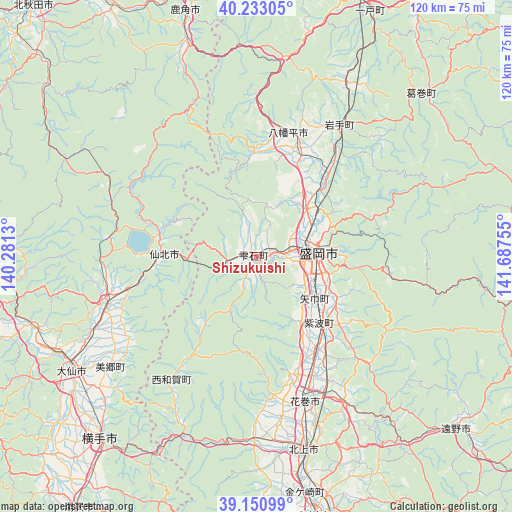
Shizukuishi GPS coordinates[2]
39° 41' 38.904" North, 140° 59' 3.912" East
| Map corner | latitude | longitude |
|---|---|---|
| Upper-left | 40.23305°, | 140.2813° |
| Center: | 39.69414°, | 140.98442° |
| Lower-right: | 39.15099°, | 141.68755° |
| Map W x H: | 120.3×120.3 km | = 74.8×74.8mi |
| max Lat: | 45.40944° ⇑7.6% North |
| Shizukuishi: | 39.69414° |
| min Lat: | ⇓92.4% South 24.34478° |
| min Long | Shizukuishi | max Long |
| 123° | 140.98442° | 145.575° |
| W 92.5%⇐ | ⇒7.5% E |
Elevation
Elevation of Shizukuishi is 192 m = 630 ft, and this is 107.4 m = 352 ft above average elevation for this country.
| Max E: |
1086 m = 3563 ft | 12.9% |
| Shizukuishi | 192 m 630 ft | |
| Avg. | 84.6 m = 278 ft | |
Min E: |
-2 m = -7 ft | 87.1% |
See also: Japan elevation on elevation.city.
Geographical zone
Shizukuishi is located in North temperate zone (between Tropic of Cancer and the Arctic Circle). Distance of this Northern Tropic circle is 1807.7 km =1123.3 mi to South.| Distance of | km | miles | from Shizukuishi |
|---|---|---|---|
| North Pole | 5593.5 | 3475.6 | to North |
| Arctic Circle | 2987.6 | 1856.4 | to North |
| Tropic Cancer | 1807.7 | 1123.3 | to South |
| Equator | 4413.6 | 2742.5 | to South |


Nearby cities:
15 places around Shizukuishi: (largest is in red/bold)
• Daisen
50.9 km =31.6 mi,  236°
236°
• Hachimantai
26 km =16.2 mi,  28°
28°
• Hanamaki
36.4 km =22.6 mi,  161°
161°
• Hanawa
57 km =35.4 mi,  342°
342°
• Kakunodatemachi
37.6 km =23.4 mi,  251°
251°
• Kazuno
59.7 km =37.1 mi, 343°
• Kitakami
47.1 km =29.3 mi,  166°
166°
• Mizusawa
63.7 km =39.6 mi, 168°
• Morioka
14.2 km =8.8 mi,  87°
87°
• Semboku
20.4 km =12.7 mi,  274°
274°
• Takizawa
17.6 km =10.9 mi,  46°
46°
• Tōno
63.1 km =39.2 mi,  131°
131°
• Yokote
56.1 km =34.9 mi,  221°
221°
• Ōmagari
50.8 km =31.6 mi, 237°
• Ōshū
63.7 km =39.6 mi, 165°
Sources, notices
• [Note1] Compared only with cities in Japan existing in our database
• [Src1] Map data: © OpenStreetMap contributors (CC-BY-SA)
• [Src2] Other city data from geonames.org with taken over terms of usage.
• [Src3] Geographical zone / Annual Mean Temperature by Robert A. Rohde @ Wikipedia
