Hanawa geodata
Hanawa (Akita) is a populated place; located in Japan in Asia/Tokyo (GMT+9) time zone. With population of 36,925 people, there are 484 cities with bigger population in this country. Compared to other cities in Japan, 93.2% of cities are located further ↓South; 91.1% of cities are located further ←West and 82.4% of cities have lower elevation than Hanawa. Note1


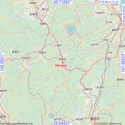
Hanawa GPS coordinates[2]
40° 11' 0.996" North, 140° 47' 13.992" East
| Map corner | latitude | longitude |
|---|---|---|
| Upper-left | 40.71865°, | 140.0841° |
| Center: | 40.18361°, | 140.78722° |
| Lower-right: | 39.64431°, | 141.49035° |
| Map W x H: | 119.5×119.5 km | = 74.3×74.3mi |
| max Lat: | 45.40944° ⇑6.8% North |
| Hanawa: | 40.18361° |
| min Lat: | ⇓93.2% South 24.34478° |
| min Long | Hanawa | max Long |
| 123° | 140.78722° | 145.575° |
| W 91.1%⇐ | ⇒8.9% E |
Elevation
Elevation of Hanawa is 144 m = 472 ft, and this is 59.4 m = 195 ft above average elevation for this country.
| Max E: |
1086 m = 3563 ft | 17.6% |
| Hanawa | 144 m 472 ft | |
| Avg. | 84.6 m = 278 ft | |
Min E: |
-2 m = -7 ft | 82.4% |
See also: Japan elevation on elevation.city.
Geographical zone
Hanawa is located in North temperate zone (between Tropic of Cancer and the Arctic Circle). Distance of this Northern Tropic circle is 1862.1 km =1157.1 mi to South.| Distance of | km | miles | from Hanawa |
|---|---|---|---|
| North Pole | 5539.1 | 3441.8 | to North |
| Arctic Circle | 2933.2 | 1822.6 | to North |
| Tropic Cancer | 1862.1 | 1157.1 | to South |
| Equator | 4468 | 2776.3 | to South |


Nearby cities:
15 places around Hanawa: (largest is in red/bold)
• Furudate
58.4 km =36.3 mi,  48°
48°
• Hachimantai
43 km =26.7 mi,  137°
137°
• Hirakawa
48.5 km =30.1 mi,  337°
337°
• Hirosaki
52.8 km =32.8 mi,  329°
329°
• Ichinohe
42.9 km =26.7 mi,  84°
84°
• Kazuno
2.8 km =1.7 mi,  353°
353°
• Kita-Akita
33.5 km =20.8 mi,  273°
273°
• Kuroishi
48.5 km =30.1 mi, 351°
• Kuroishi
54.2 km =33.7 mi, 341°
• Ninohe
46.2 km =28.7 mi, 75°
• Semboku
52.9 km =32.9 mi,  183°
183°
• Shizukuishi
57 km =35.4 mi,  162°
162°
• Takanosu
36 km =22.4 mi,  276°
276°
• Takizawa
51.7 km =32.1 mi,  145°
145°
• Ōdate
21.8 km =13.5 mi,  296°
296°
Sources, notices
• [Note1] Compared only with cities in Japan existing in our database
• [Src1] Map data: © OpenStreetMap contributors (CC-BY-SA)
• [Src2] Other city data from geonames.org with taken over terms of usage.
• [Src3] Geographical zone / Annual Mean Temperature by Robert A. Rohde @ Wikipedia
