Ōmagari geodata
Ōmagari (Akita) is a populated place; located in Japan in Asia/Tokyo (GMT+9) time zone. With population of 38,805 people, there are 467 cities with bigger population in this country. Compared to other cities in Japan, 92% of cities are located further ↓South; 86.6% of cities are located further ←West and 50.1% of cities have higher elevation than Ōmagari. Note1


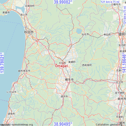
Ōmagari GPS coordinates[2]
39° 27' 0" North, 140° 28' 59.988" East
| Map corner | latitude | longitude |
|---|---|---|
| Upper-left | 39.99082°, | 139.78021° |
| Center: | 39.45°, | 140.48333° |
| Lower-right: | 38.90495°, | 141.18646° |
| Map W x H: | 120.7×120.7 km | = 75×75mi |
| max Lat: | 45.40944° ⇑8% North |
| Ōmagari: | 39.45° |
| min Lat: | ⇓92% South 24.34478° |
| min Long | Ōmagari | max Long |
| 123° | 140.48333° | 145.575° |
| W 86.6%⇐ | ⇒13.4% E |
Elevation
Elevation of Ōmagari is 28 m = 92 ft, and this is 56.6 m = 186 ft below average elevation for this country.
| Max E: |
1086 m = 3563 ft | 50.1% |
| Avg. | 84.6 m = 278 ft | |
| Ōmagari | 28 m = 92 ft | |
Min E: |
-2 m = -7 ft | 49.9% |
See also: Japan elevation on elevation.city.
Geographical zone
Ōmagari is located in North temperate zone (between Tropic of Cancer and the Arctic Circle). Distance of this Northern Tropic circle is 1780.5 km =1106.4 mi to South.| Distance of | km | miles | from Ōmagari |
|---|---|---|---|
| North Pole | 5620.6 | 3492.5 | to North |
| Arctic Circle | 3014.7 | 1873.2 | to North |
| Tropic Cancer | 1780.5 | 1106.4 | to South |
| Equator | 4386.4 | 2725.6 | to South |


Nearby cities:
15 places around Ōmagari: (largest is in red/bold)
• Akita
43.2 km =26.8 mi,  313°
313°
• Daisen
1.1 km =0.7 mi,  151°
151°
• Hanamaki
54.9 km =34.1 mi,  97°
97°
• Kakunodatemachi
17.1 km =10.6 mi,  24°
24°
• Katagami
63.2 km =39.3 mi,  318°
318°
• Kitakami
57.5 km =35.7 mi,  108°
108°
• Mizusawa
66.1 km =41.1 mi,  122°
122°
• Morioka
63.5 km =39.5 mi,  64°
64°
• Nikaho
50.8 km =31.6 mi,  246°
246°
• Semboku
36.6 km =22.7 mi,  38°
38°
• Shizukuishi
50.8 km =31.6 mi, 57°
• Tennō
66.8 km =41.5 mi, 318°
• Yokote
15.9 km =9.9 mi,  158°
158°
• Yurihonjō
37.1 km =23.1 mi,  259°
259°
• Yuzawa
31.5 km =19.6 mi,  177°
177°
Sources, notices
• [Note1] Compared only with cities in Japan existing in our database
• [Src1] Map data: © OpenStreetMap contributors (CC-BY-SA)
• [Src2] Other city data from geonames.org with taken over terms of usage.
• [Src3] Geographical zone / Annual Mean Temperature by Robert A. Rohde @ Wikipedia
