Hachimantai geodata
Hachimantai (Iwate) is a seat of a second-order administrative division; located in Japan in Asia/Tokyo (GMT+9) time zone. In our database, there are 767 cities with bigger population. Compared to other cities in Japan, 93% of cities are located further ↓South; 93.5% of cities are located further ←West and 90.2% of cities have lower elevation than Hachimantai. Note1


Hachimantai GPS coordinates[2]
39° 53' 59.244" North, 141° 7' 47.604" East
| Map corner | latitude | longitude |
|---|---|---|
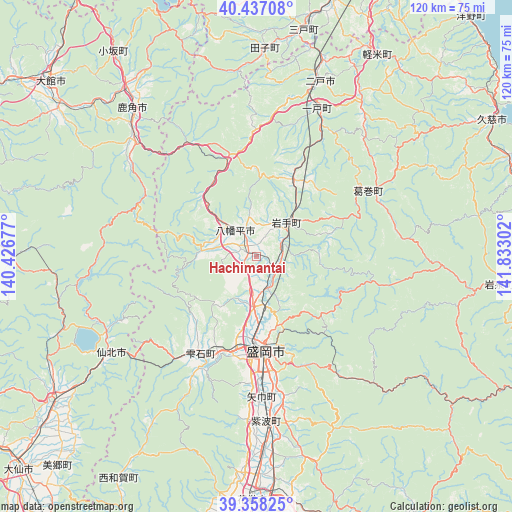
| Upper-left | 40.43708°, | 140.42677° |
| Center: | 39.89979°, | 141.12989° |
| Lower-right: | 39.35825°, | 141.83302° |
| Map W x H: | 120×120 km | = 74.6×74.6mi |
| max Lat: | 45.40944° ⇑7% North |
| Hachimantai: | 39.89979° |
| min Lat: | ⇓93% South 24.34478° |
| min Long | Hachimantai | max Long |
| 123° | 141.12989° | 145.575° |
| W 93.5%⇐ | ⇒6.5% E |
Elevation
Elevation of Hachimantai is 228 m = 748 ft, and this is 143.4 m = 470 ft above average elevation for this country.
| Max E: |
1086 m = 3563 ft | 9.8% |
| Hachimantai | 228 m 748 ft | |
| Avg. | 84.6 m = 278 ft | |
Min E: |
-2 m = -7 ft | 90.2% |
See also: Japan elevation on elevation.city.
Geographical zone
Hachimantai is located in North temperate zone (between Tropic of Cancer and the Arctic Circle). Distance of this Northern Tropic circle is 1830.5 km =1137.4 mi to South.| Distance of | km | miles | from Hachimantai |
|---|---|---|---|
| North Pole | 5570.6 | 3461.4 | to North |
| Arctic Circle | 2964.7 | 1842.2 | to North |
| Tropic Cancer | 1830.5 | 1137.4 | to South |
| Equator | 4436.4 | 2756.7 | to South |


Nearby cities:
15 places around Hachimantai: (largest is in red/bold)
• Furudate
71.6 km =44.5 mi,  12°
12°
• Hanamaki
57.4 km =35.7 mi,  181°
181°
• Hanawa
43 km =26.7 mi,  317°
317°
• Ichinohe
38.1 km =23.7 mi,  20°
20°
• Kakunodatemachi
59.2 km =36.8 mi,  234°
234°
• Kazuno
45.2 km =28.1 mi, 319°
• Kita-Akita
71 km =44.1 mi,  298°
298°
• Kitakami
68.6 km =42.6 mi, 180°
• Kuji
63.1 km =39.2 mi,  59°
59°
• Morioka
22.3 km =13.9 mi, 175°
• Ninohe
46.2 km =28.7 mi, 19°
• Semboku
39 km =24.2 mi,  237°
237°
• Shizukuishi
26 km =16.2 mi,  208°
208°
• Takizawa
10.8 km =6.7 mi, 177°
• Ōdate
63.9 km =39.7 mi,  310°
310°
Sources, notices
• [Note1] Compared only with cities in Japan existing in our database
• [Src1] Map data: © OpenStreetMap contributors (CC-BY-SA)
• [Src2] Other city data from geonames.org with taken over terms of usage.
• [Src3] Geographical zone / Annual Mean Temperature by Robert A. Rohde @ Wikipedia
