Okunoya geodata
Okunoya (Ibaraki) is a populated place; located in Japan in Asia/Tokyo (GMT+9) time zone. With population of 34,627 people, there are 501 cities with bigger population in this country. Compared to other cities in Japan, 73.1% of cities are located further ↓South; 85.7% of cities are located further ←West and 56.6% of cities have higher elevation than Okunoya. Note1


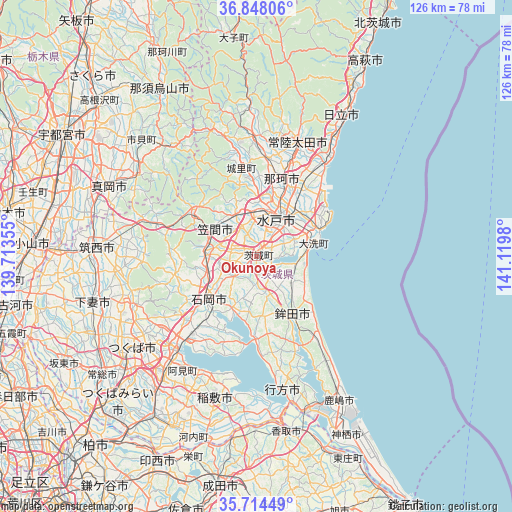
Okunoya GPS coordinates[2]
36° 16' 59.988" North, 140° 25' 0.012" East
| Map corner | latitude | longitude |
|---|---|---|
| Upper-left | 36.84806°, | 139.71355° |
| Center: | 36.28333°, | 140.41667° |
| Lower-right: | 35.71449°, | 141.1198° |
| Map W x H: | 126×126 km | = 78.3×78.3mi |
| max Lat: | 45.40944° ⇑26.9% North |
| Okunoya: | 36.28333° |
| min Lat: | ⇓73.1% South 24.34478° |
| min Long | Okunoya | max Long |
| 123° | 140.41667° | 145.575° |
| W 85.7%⇐ | ⇒14.3% E |
Elevation
Elevation of Okunoya is 22 m = 72 ft, and this is 62.6 m = 205 ft below average elevation for this country.
| Max E: |
1086 m = 3563 ft | 56.6% |
| Avg. | 84.6 m = 278 ft | |
| Okunoya | 22 m = 72 ft | |
Min E: |
-2 m = -7 ft | 43.4% |
See also: Japan elevation on elevation.city.
Geographical zone
Okunoya is located in North temperate zone (between Tropic of Cancer and the Arctic Circle). Distance of this Northern Tropic circle is 1428.4 km =887.6 mi to South.| Distance of | km | miles | from Okunoya |
|---|---|---|---|
| North Pole | 5972.7 | 3711.3 | to North |
| Arctic Circle | 3366.8 | 2092 | to North |
| Tropic Cancer | 1428.4 | 887.6 | to South |
| Equator | 4034.3 | 2506.8 | to South |


Nearby cities:
15 places around Okunoya: (largest is in red/bold)
• Funaishikawa
24.4 km =15.2 mi,  33°
33°
• Hitachi-Naka
16.4 km =10.2 mi,  40°
40°
• Hokota
17.3 km =10.7 mi,  148°
148°
• Ishioka
17.5 km =10.9 mi,  230°
230°
• Iwase
29.3 km =18.2 mi,  284°
284°
• Kasama
17.4 km =10.8 mi,  309°
309°
• Kasumigaura
21 km =13 mi, 226°
• Katsuta
15.3 km =9.5 mi, 43°
• Makabe
28.4 km =17.6 mi,  266°
266°
• Mito
8 km =5 mi,  21°
21°
• Omitama
4.6 km =2.9 mi, 226°
• Sakuragawa
27.2 km =16.9 mi,  262°
262°
• Tomobe
12.8 km =8 mi, 305°
• Tsuchiura
28.3 km =17.6 mi,  220°
220°
• Ōarai
15.4 km =9.6 mi,  77°
77°
Sources, notices
• [Note1] Compared only with cities in Japan existing in our database
• [Src1] Map data: © OpenStreetMap contributors (CC-BY-SA)
• [Src2] Other city data from geonames.org with taken over terms of usage.
• [Src3] Geographical zone / Annual Mean Temperature by Robert A. Rohde @ Wikipedia
