Nagai geodata
Nagai (Yamagata) is a seat of a second-order administrative division; located in Japan in Asia/Tokyo (GMT+9) time zone. With population of 31,026 people, there are 539 cities with bigger population in this country. Compared to other cities in Japan, 87.7% of cities are located further ↓South; 79.4% of cities are located further ←West and 88.5% of cities have lower elevation than Nagai. Note1


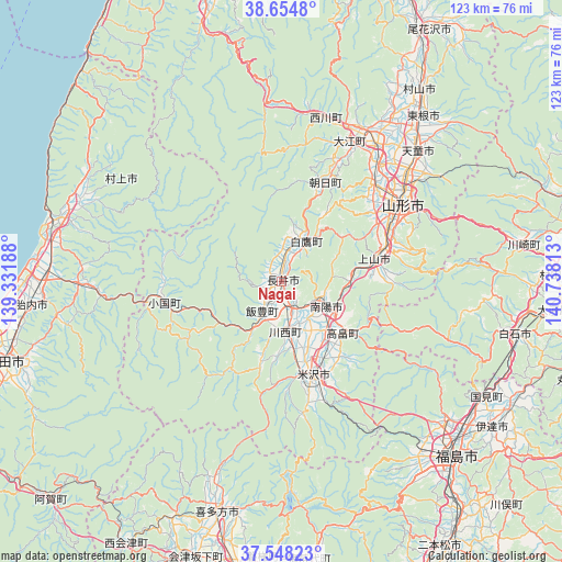
Nagai GPS coordinates[2]
38° 6' 12.996" North, 140° 2' 6" East
| Map corner | latitude | longitude |
|---|---|---|
| Upper-left | 38.6548°, | 139.33188° |
| Center: | 38.10361°, | 140.035° |
| Lower-right: | 37.54823°, | 140.73813° |
| Map W x H: | 123×123 km | = 76.4×76.4mi |
| max Lat: | 45.40944° ⇑12.3% North |
| Nagai: | 38.10361° |
| min Lat: | ⇓87.7% South 24.34478° |
| min Long | Nagai | max Long |
| 123° | 140.035° | 145.575° |
| W 79.4%⇐ | ⇒20.6% E |
Elevation
Elevation of Nagai is 204 m = 669 ft, and this is 119.4 m = 392 ft above average elevation for this country.
| Max E: |
1086 m = 3563 ft | 11.5% |
| Nagai | 204 m 669 ft | |
| Avg. | 84.6 m = 278 ft | |
Min E: |
-2 m = -7 ft | 88.5% |
See also: Japan elevation on elevation.city.
Geographical zone
Nagai is located in North temperate zone (between Tropic of Cancer and the Arctic Circle). Distance of this Northern Tropic circle is 1630.8 km =1013.3 mi to South.| Distance of | km | miles | from Nagai |
|---|---|---|---|
| North Pole | 5770.3 | 3585.5 | to North |
| Arctic Circle | 3164.4 | 1966.3 | to North |
| Tropic Cancer | 1630.8 | 1013.3 | to South |
| Equator | 4236.7 | 2632.6 | to South |


Nearby cities:
15 places around Nagai: (largest is in red/bold)
• Date
51.8 km =32.2 mi,  128°
128°
• Fukushima
54.6 km =33.9 mi,  136°
136°
• Higashine
49.1 km =30.5 mi,  40°
40°
• Hobaramachi
55.3 km =34.4 mi, 125°
• Kaminoyama
21.6 km =13.4 mi,  75°
75°
• Kitakata
52.6 km =32.7 mi,  196°
196°
• Murakami
50.3 km =31.3 mi,  286°
286°
• Murayama
52.5 km =32.6 mi, 39°
• Nanyō
9.6 km =6 mi, 134°
• Sagae
36.4 km =22.6 mi,  34°
34°
• Shiroishi
52.3 km =32.5 mi,  102°
102°
• Takahata
17.7 km =11 mi, 129°
• Tendō
40.3 km =25 mi,  46°
46°
• Yamagata
32.4 km =20.1 mi,  63°
63°
• Yonezawa
22.7 km =14.1 mi,  161°
161°
Sources, notices
• [Note1] Compared only with cities in Japan existing in our database
• [Src1] Map data: © OpenStreetMap contributors (CC-BY-SA)
• [Src2] Other city data from geonames.org with taken over terms of usage.
• [Src3] Geographical zone / Annual Mean Temperature by Robert A. Rohde @ Wikipedia
