Higashine geodata
Higashine (Yamagata) is a seat of a second-order administrative division; located in Japan in Asia/Tokyo (GMT+9) time zone. With population of 45,779 people, there are 401 cities with bigger population in this country. Compared to other cities in Japan, 89.3% of cities are located further ↓South; 85% of cities are located further ←West and 79.4% of cities have lower elevation than Higashine. Note1


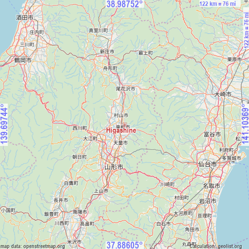
Higashine GPS coordinates[2]
38° 26' 20.004" North, 140° 24' 2.016" East
| Map corner | latitude | longitude |
|---|---|---|
| Upper-left | 38.98752°, | 139.69744° |
| Center: | 38.43889°, | 140.40056° |
| Lower-right: | 37.88605°, | 141.10369° |
| Map W x H: | 122.5×122.5 km | = 76.1×76.1mi |
| max Lat: | 45.40944° ⇑10.7% North |
| Higashine: | 38.43889° |
| min Lat: | ⇓89.3% South 24.34478° |
| min Long | Higashine | max Long |
| 123° | 140.40056° | 145.575° |
| W 85%⇐ | ⇒15% E |
Elevation
Elevation of Higashine is 119 m = 390 ft, and this is 34.4 m = 113 ft above average elevation for this country.
| Max E: |
1086 m = 3563 ft | 20.6% |
| Higashine | 119 m 390 ft | |
| Avg. | 84.6 m = 278 ft | |
Min E: |
-2 m = -7 ft | 79.4% |
See also: Higashine elevation on elevation.city.
Geographical zone
Higashine is located in North temperate zone (between Tropic of Cancer and the Arctic Circle). Distance of this Northern Tropic circle is 1668.1 km =1036.5 mi to South.| Distance of | km | miles | from Higashine |
|---|---|---|---|
| North Pole | 5733.1 | 3562.4 | to North |
| Arctic Circle | 3127.2 | 1943.2 | to North |
| Tropic Cancer | 1668.1 | 1036.5 | to South |
| Equator | 4274 | 2655.7 | to South |


Nearby cities:
15 places around Higashine: (largest is in red/bold)
• Furukawa
50.5 km =31.4 mi,  73°
73°
• Kaminoyama
33.6 km =20.9 mi,  199°
199°
• Murayama
3.6 km =2.2 mi,  19°
19°
• Nagai
49.1 km =30.5 mi,  220°
220°
• Nanyō
50.7 km =31.5 mi,  209°
209°
• Natori-shi
51.9 km =32.2 mi,  125°
125°
• Obanazawa
18.3 km =11.4 mi,  0°
0°
• Rifu
51.6 km =32.1 mi,  103°
103°
• Sagae
13.4 km =8.3 mi,  236°
236°
• Sendai
44.9 km =27.9 mi,  115°
115°
• Shinjō
36.6 km =22.7 mi,  346°
346°
• Takahata
51.9 km =32.2 mi, 200°
• Tendō
9.9 km =6.2 mi, 195°
• Tomiya
42.6 km =26.5 mi, 96°
• Yamagata
23 km =14.3 mi,  187°
187°
Sources, notices
• [Note1] Compared only with cities in Japan existing in our database
• [Src1] Map data: © OpenStreetMap contributors (CC-BY-SA)
• [Src2] Other city data from geonames.org with taken over terms of usage.
• [Src3] Geographical zone / Annual Mean Temperature by Robert A. Rohde @ Wikipedia
