Sagae geodata
Sagae (Yamagata) is a seat of a second-order administrative division; located in Japan in Asia/Tokyo (GMT+9) time zone. With population of 43,544 people, there are 416 cities with bigger population in this country. Compared to other cities in Japan, 88.7% of cities are located further ↓South; 82.8% of cities are located further ←West and 76.2% of cities have lower elevation than Sagae. Note1


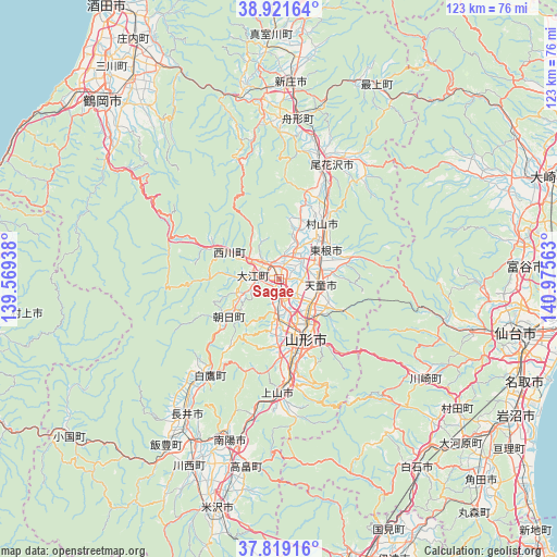
Sagae GPS coordinates[2]
38° 22' 21" North, 140° 16' 21" East
| Map corner | latitude | longitude |
|---|---|---|
| Upper-left | 38.92164°, | 139.56938° |
| Center: | 38.3725°, | 140.2725° |
| Lower-right: | 37.81916°, | 140.97563° |
| Map W x H: | 122.6×122.6 km | = 76.2×76.2mi |
| max Lat: | 45.40944° ⇑11.3% North |
| Sagae: | 38.3725° |
| min Lat: | ⇓88.7% South 24.34478° |
| min Long | Sagae | max Long |
| 123° | 140.2725° | 145.575° |
| W 82.8%⇐ | ⇒17.2% E |
Elevation
Elevation of Sagae is 102 m = 335 ft, and this is 17.4 m = 57 ft above average elevation for this country.
| Max E: |
1086 m = 3563 ft | 23.8% |
| Sagae | 102 m 335 ft | |
| Avg. | 84.6 m = 278 ft | |
Min E: |
-2 m = -7 ft | 76.2% |
See also: Sagae elevation on elevation.city.
Geographical zone
Sagae is located in North temperate zone (between Tropic of Cancer and the Arctic Circle). Distance of this Northern Tropic circle is 1660.7 km =1031.9 mi to South.| Distance of | km | miles | from Sagae |
|---|---|---|---|
| North Pole | 5740.4 | 3566.9 | to North |
| Arctic Circle | 3134.6 | 1947.7 | to North |
| Tropic Cancer | 1660.7 | 1031.9 | to South |
| Equator | 4266.6 | 2651.1 | to South |


Nearby cities:
15 places around Sagae: (largest is in red/bold)
• Higashine
13.4 km =8.3 mi,  56°
56°
• Kaminoyama
24.3 km =15.1 mi,  179°
179°
• Murayama
16.4 km =10.2 mi,  48°
48°
• Nagai
36.4 km =22.6 mi,  214°
214°
• Nanyō
39.2 km =24.4 mi,  200°
200°
• Obanazawa
28 km =17.4 mi,  23°
23°
• Sendai
53.2 km =33.1 mi,  102°
102°
• Shinjō
43 km =26.7 mi,  3°
3°
• Shiroishi
51 km =31.7 mi,  143°
143°
• Takahata
41.8 km =26 mi,  189°
189°
• Tendō
8.7 km =5.4 mi, 103°
• Tomiya
53.5 km =33.2 mi,  87°
87°
• Yamagata
17.5 km =10.9 mi,  152°
152°
• Yonezawa
53.2 km =33.1 mi, 194°
• Ōkawara
53.9 km =33.5 mi,  131°
131°
Sources, notices
• [Note1] Compared only with cities in Japan existing in our database
• [Src1] Map data: © OpenStreetMap contributors (CC-BY-SA)
• [Src2] Other city data from geonames.org with taken over terms of usage.
• [Src3] Geographical zone / Annual Mean Temperature by Robert A. Rohde @ Wikipedia
