Tendō geodata
Tendō (Yamagata) is a seat of a second-order administrative division; located in Japan in Asia/Tokyo (GMT+9) time zone. With population of 65,393 people, there are 300 cities with bigger population in this country. Compared to other cities in Japan, 88.6% of cities are located further ↓South; 84.3% of cities are located further ←West and 78% of cities have lower elevation than Tendō. Note1


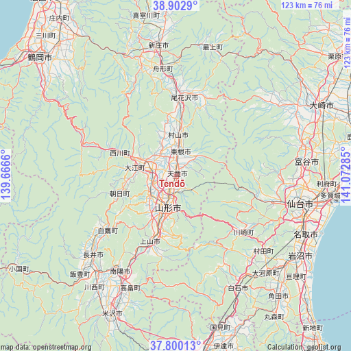
Tendō GPS coordinates[2]
38° 21' 12.996" North, 140° 22' 10.992" East
| Map corner | latitude | longitude |
|---|---|---|
| Upper-left | 38.9029°, | 139.6666° |
| Center: | 38.35361°, | 140.36972° |
| Lower-right: | 37.80013°, | 141.07285° |
| Map W x H: | 122.6×122.6 km | = 76.2×76.2mi |
| max Lat: | 45.40944° ⇑11.4% North |
| Tendō: | 38.35361° |
| min Lat: | ⇓88.6% South 24.34478° |
| min Long | Tendō | max Long |
| 123° | 140.36972° | 145.575° |
| W 84.3%⇐ | ⇒15.7% E |
Elevation
Elevation of Tendō is 108 m = 354 ft, and this is 23.4 m = 77 ft above average elevation for this country.
| Max E: |
1086 m = 3563 ft | 22% |
| Tendō | 108 m 354 ft | |
| Avg. | 84.6 m = 278 ft | |
Min E: |
-2 m = -7 ft | 78% |
See also: Tendō elevation on elevation.city.
Geographical zone
Tendō is located in North temperate zone (between Tropic of Cancer and the Arctic Circle). Distance of this Northern Tropic circle is 1658.6 km =1030.6 mi to South.| Distance of | km | miles | from Tendō |
|---|---|---|---|
| North Pole | 5742.5 | 3568.2 | to North |
| Arctic Circle | 3136.7 | 1949.1 | to North |
| Tropic Cancer | 1658.6 | 1030.6 | to South |
| Equator | 4264.5 | 2649.8 | to South |


Nearby cities:
15 places around Tendō: (largest is in red/bold)
• Higashine
9.9 km =6.2 mi,  15°
15°
• Kaminoyama
23.7 km =14.7 mi,  200°
200°
• Murayama
13.5 km =8.4 mi, 16°
• Nagai
40.3 km =25 mi,  226°
226°
• Nanyō
41.2 km =25.6 mi,  213°
213°
• Natori-shi
49.4 km =30.7 mi,  114°
114°
• Obanazawa
27.9 km =17.3 mi,  5°
5°
• Sagae
8.7 km =5.4 mi,  283°
283°
• Sendai
44.4 km =27.6 mi,  102°
102°
• Shinjō
45.4 km =28.2 mi,  352°
352°
• Shiroishi
44.6 km =27.7 mi,  150°
150°
• Takahata
42 km =26.1 mi, 201°
• Tomiya
45.2 km =28.1 mi,  84°
84°
• Yamagata
13.4 km =8.3 mi,  181°
181°
• Ōkawara
46.4 km =28.8 mi,  136°
136°
Sources, notices
• [Note1] Compared only with cities in Japan existing in our database
• [Src1] Map data: © OpenStreetMap contributors (CC-BY-SA)
• [Src2] Other city data from geonames.org with taken over terms of usage.
• [Src3] Geographical zone / Annual Mean Temperature by Robert A. Rohde @ Wikipedia
