Nanyō geodata
Nanyō (Yamagata) is a seat of a second-order administrative division; located in Japan in Asia/Tokyo (GMT+9) time zone. In our database, there are 767 cities with bigger population. Compared to other cities in Japan, 87.3% of cities are located further ↓South; 80.6% of cities are located further ←West and 89.4% of cities have lower elevation than Nanyō. Note1


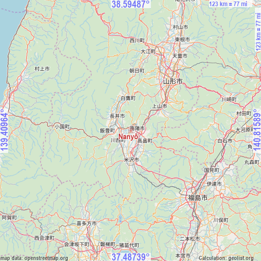
Nanyō GPS coordinates[2]
38° 2' 35.592" North, 140° 6' 45.936" East
| Map corner | latitude | longitude |
|---|---|---|
| Upper-left | 38.59487°, | 139.40964° |
| Center: | 38.04322°, | 140.11276° |
| Lower-right: | 37.48739°, | 140.81589° |
| Map W x H: | 123.1×123.1 km | = 76.5×76.5mi |
| max Lat: | 45.40944° ⇑12.7% North |
| Nanyō: | 38.04322° |
| min Lat: | ⇓87.3% South 24.34478° |
| min Long | Nanyō | max Long |
| 123° | 140.11276° | 145.575° |
| W 80.6%⇐ | ⇒19.4% E |
Elevation
Elevation of Nanyō is 212 m = 696 ft, and this is 127.4 m = 418 ft above average elevation for this country.
| Max E: |
1086 m = 3563 ft | 10.6% |
| Nanyō | 212 m 696 ft | |
| Avg. | 84.6 m = 278 ft | |
Min E: |
-2 m = -7 ft | 89.4% |
See also: Japan elevation on elevation.city.
Geographical zone
Nanyō is located in North temperate zone (between Tropic of Cancer and the Arctic Circle). Distance of this Northern Tropic circle is 1624.1 km =1009.2 mi to South.| Distance of | km | miles | from Nanyō |
|---|---|---|---|
| North Pole | 5777.1 | 3589.7 | to North |
| Arctic Circle | 3171.2 | 1970.5 | to North |
| Tropic Cancer | 1624.1 | 1009.2 | to South |
| Equator | 4230 | 2628.4 | to South |


Nearby cities:
15 places around Nanyō: (largest is in red/bold)
• Date
42.3 km =26.3 mi,  126°
126°
• Fukushima
45 km =28 mi,  136°
136°
• Higashine
50.7 km =31.5 mi,  29°
29°
• Hobaramachi
45.9 km =28.5 mi,  123°
123°
• Inawashiro
53 km =32.9 mi,  179°
179°
• Kaminoyama
18.7 km =11.6 mi,  48°
48°
• Kitakata
48.8 km =30.3 mi,  206°
206°
• Nagai
9.6 km =6 mi,  314°
314°
• Sagae
39.2 km =24.4 mi,  20°
20°
• Shiroishi
44.5 km =27.7 mi,  95°
95°
• Takahata
8.2 km =5.1 mi, 123°
• Tendō
41.2 km =25.6 mi, 33°
• Yamagata
30.7 km =19.1 mi, 46°
• Yanagawamachi-saiwaichō
47.8 km =29.7 mi, 116°
• Yonezawa
14.8 km =9.2 mi, 178°
Sources, notices
• [Note1] Compared only with cities in Japan existing in our database
• [Src1] Map data: © OpenStreetMap contributors (CC-BY-SA)
• [Src2] Other city data from geonames.org with taken over terms of usage.
• [Src3] Geographical zone / Annual Mean Temperature by Robert A. Rohde @ Wikipedia
