Ōtsuchi geodata
Ōtsuchi (Iwate) is a populated place; located in Japan in Asia/Tokyo (GMT+9) time zone. With population of 16,497 people, there are 731 cities with bigger population in this country. Compared to other cities in Japan, 91.7% of cities are located further ↓South; 97.4% of cities are located further ←West and 89.6% of cities have higher elevation than Ōtsuchi. Note1


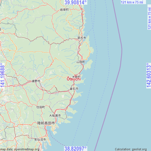
Ōtsuchi GPS coordinates[2]
39° 22' 0.012" North, 141° 54' 0" East
| Map corner | latitude | longitude |
|---|---|---|
| Upper-left | 39.90814°, | 141.19688° |
| Center: | 39.36667°, | 141.9° |
| Lower-right: | 38.82097°, | 142.60313° |
| Map W x H: | 120.9×120.9 km | = 75.1×75.1mi |
| max Lat: | 45.40944° ⇑8.3% North |
| Ōtsuchi: | 39.36667° |
| min Lat: | ⇓91.7% South 24.34478° |
| min Long | Ōtsuchi | max Long |
| 123° | 141.9° | 145.575° |
| W 97.4%⇐ | ⇒2.6% E |
Elevation
Elevation of Ōtsuchi is 5 m = 16 ft, and this is 79.6 m = 261 ft below average elevation for this country.
| Max E: |
1086 m = 3563 ft | 89.6% |
| Avg. | 84.6 m = 278 ft | |
| Ōtsuchi | 5 m = 16 ft | |
Min E: |
-2 m = -7 ft | 10.4% |
See also: Japan elevation on elevation.city.
Geographical zone
Ōtsuchi is located in North temperate zone (between Tropic of Cancer and the Arctic Circle). Distance of this Northern Tropic circle is 1771.2 km =1100.6 mi to South.| Distance of | km | miles | from Ōtsuchi |
|---|---|---|---|
| North Pole | 5629.9 | 3498.3 | to North |
| Arctic Circle | 3024 | 1879 | to North |
| Tropic Cancer | 1771.2 | 1100.6 | to South |
| Equator | 4377.2 | 2719.9 | to South |


Nearby cities:
15 places around Ōtsuchi: (largest is in red/bold)
• Hanamaki
67.4 km =41.9 mi,  271°
271°
• Ichinoseki
82.9 km =51.5 mi,  232°
232°
• Kamaishi
10.3 km =6.4 mi,  195°
195°
• Kesennuma
58.8 km =36.5 mi,  208°
208°
• Kitakami
68 km =42.3 mi,  262°
262°
• Miyako
31.4 km =19.5 mi,  6°
6°
• Mizusawa
70.9 km =44.1 mi,  248°
248°
• Morioka
74.2 km =46.1 mi,  299°
299°
• Rikuzentakata
44.8 km =27.8 mi,  215°
215°
• Shizukuishi
86.6 km =53.8 mi,  294°
294°
• Takizawa
81.6 km =50.7 mi,  306°
306°
• Tōno
32 km =19.9 mi, 260°
• Yamada
11.9 km =7.4 mi,  21°
21°
• Ōfunato
36.4 km =22.6 mi, 205°
• Ōshū
67.9 km =42.2 mi, 248°
Sources, notices
• [Note1] Compared only with cities in Japan existing in our database
• [Src1] Map data: © OpenStreetMap contributors (CC-BY-SA)
• [Src2] Other city data from geonames.org with taken over terms of usage.
• [Src3] Geographical zone / Annual Mean Temperature by Robert A. Rohde @ Wikipedia
