Yamada geodata
Yamada (Iwate) is a populated place; located in Japan in Asia/Tokyo (GMT+9) time zone. With population of 20,144 people, there are 693 cities with bigger population in this country. Compared to other cities in Japan, 92.1% of cities are located further ↓South; 97.8% of cities are located further ←West and 93.5% of cities have higher elevation than Yamada. Note1


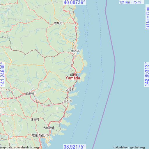
Yamada GPS coordinates[2]
39° 28' 0.012" North, 141° 57' 0" East
| Map corner | latitude | longitude |
|---|---|---|
| Upper-left | 40.00736°, | 141.24688° |
| Center: | 39.46667°, | 141.95° |
| Lower-right: | 38.92175°, | 142.65313° |
| Map W x H: | 120.7×120.7 km | = 75×75mi |
| max Lat: | 45.40944° ⇑7.9% North |
| Yamada: | 39.46667° |
| min Lat: | ⇓92.1% South 24.34478° |
| min Long | Yamada | max Long |
| 123° | 141.95° | 145.575° |
| W 97.8%⇐ | ⇒2.2% E |
Elevation
Elevation of Yamada is 4 m = 13 ft, and this is 80.6 m = 264 ft below average elevation for this country.
| Max E: |
1086 m = 3563 ft | 93.5% |
| Avg. | 84.6 m = 278 ft | |
| Yamada | 4 m = 13 ft | |
Min E: |
-2 m = -7 ft | 6.5% |
See also: Japan elevation on elevation.city.
Geographical zone
Yamada is located in North temperate zone (between Tropic of Cancer and the Arctic Circle). Distance of this Northern Tropic circle is 1782.4 km =1107.5 mi to South.| Distance of | km | miles | from Yamada |
|---|---|---|---|
| North Pole | 5618.8 | 3491.4 | to North |
| Arctic Circle | 3012.9 | 1872.1 | to North |
| Tropic Cancer | 1782.4 | 1107.5 | to South |
| Equator | 4388.3 | 2726.8 | to South |


Nearby cities:
15 places around Yamada: (largest is in red/bold)
• Hachimantai
85.1 km =52.9 mi,  304°
304°
• Hanamaki
72.2 km =44.9 mi,  262°
262°
• Kamaishi
22.2 km =13.8 mi,  198°
198°
• Kesennuma
70.6 km =43.9 mi,  207°
207°
• Kitakami
74.5 km =46.3 mi,  254°
254°
• Kuji
81.7 km =50.8 mi,  349°
349°
• Miyako
20.1 km =12.5 mi,  357°
357°
• Mizusawa
79.4 km =49.3 mi,  242°
242°
• Morioka
73.3 km =45.5 mi,  290°
290°
• Rikuzentakata
56.4 km =35 mi, 212°
• Takizawa
79.2 km =49.2 mi, 298°
• Tōno
39.5 km =24.5 mi, 245°
• Ōfunato
48.3 km =30 mi, 204°
• Ōshū
76.5 km =47.5 mi, 241°
• Ōtsuchi
11.9 km =7.4 mi, 201°
Sources, notices
• [Note1] Compared only with cities in Japan existing in our database
• [Src1] Map data: © OpenStreetMap contributors (CC-BY-SA)
• [Src2] Other city data from geonames.org with taken over terms of usage.
• [Src3] Geographical zone / Annual Mean Temperature by Robert A. Rohde @ Wikipedia
