Ōtawara geodata
Ōtawara (Tochigi) is a seat of a second-order administrative division; located in Japan in Asia/Tokyo (GMT+9) time zone. With population of 58,888 people, there are 329 cities with bigger population in this country. Compared to other cities in Japan, 81.5% of cities are located further ↓South; 79.4% of cities are located further ←West and 88.8% of cities have lower elevation than Ōtawara. Note1


Ōtawara GPS coordinates[2]
36° 52' 0.012" North, 140° 1' 59.988" East
| Map corner | latitude | longitude |
|---|---|---|
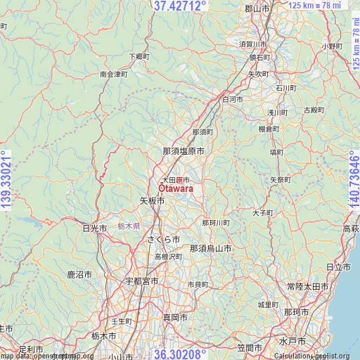
| Upper-left | 37.42712°, | 139.33021° |
| Center: | 36.86667°, | 140.03333° |
| Lower-right: | 36.30208°, | 140.73646° |
| Map W x H: | 125.1×125.1 km | = 77.7×77.7mi |
| max Lat: | 45.40944° ⇑18.5% North |
| Ōtawara: | 36.86667° |
| min Lat: | ⇓81.5% South 24.34478° |
| min Long | Ōtawara | max Long |
| 123° | 140.03333° | 145.575° |
| W 79.4%⇐ | ⇒20.6% E |
Elevation
Elevation of Ōtawara is 205 m = 673 ft, and this is 120.4 m = 395 ft above average elevation for this country.
| Max E: |
1086 m = 3563 ft | 11.2% |
| Ōtawara | 205 m 673 ft | |
| Avg. | 84.6 m = 278 ft | |
Min E: |
-2 m = -7 ft | 88.8% |
See also: Ōtawara elevation on elevation.city.
Geographical zone
Ōtawara is located in North temperate zone (between Tropic of Cancer and the Arctic Circle). Distance of this Northern Tropic circle is 1493.3 km =927.9 mi to South.| Distance of | km | miles | from Ōtawara |
|---|---|---|---|
| North Pole | 5907.9 | 3671 | to North |
| Arctic Circle | 3302 | 2051.8 | to North |
| Tropic Cancer | 1493.3 | 927.9 | to South |
| Equator | 4099.2 | 2547.1 | to South |


Nearby cities:
15 places around Ōtawara: (largest is in red/bold)
• Daigo
30.3 km =18.8 mi,  111°
111°
• Imaichi
35.3 km =21.9 mi,  241°
241°
• Kanuma
44.2 km =27.5 mi,  217°
217°
• Karasuyama
26.2 km =16.3 mi,  156°
156°
• Kuroiso
11.2 km =7 mi,  7°
7°
• Mashiko
44.9 km =27.9 mi,  172°
172°
• Motegi
41.2 km =25.6 mi, 161°
• Nasukarasuyama
26.4 km =16.4 mi,  154°
154°
• Nasushiobara
13 km =8.1 mi,  344°
344°
• Nikkō
39.3 km =24.4 mi,  250°
250°
• Sakura
16.7 km =10.4 mi,  194°
194°
• Shirakawa
34.7 km =21.6 mi,  35°
35°
• Ujiie
21.2 km =13.2 mi,  196°
196°
• Utsunomiya
35.9 km =22.3 mi, 201°
• Yaita
11.6 km =7.2 mi,  230°
230°
Sources, notices
• [Note1] Compared only with cities in Japan existing in our database
• [Src1] Map data: © OpenStreetMap contributors (CC-BY-SA)
• [Src2] Other city data from geonames.org with taken over terms of usage.
• [Src3] Geographical zone / Annual Mean Temperature by Robert A. Rohde @ Wikipedia
