Nasushiobara geodata
Nasushiobara (Tochigi) is a seat of a second-order administrative division; located in Japan in Asia/Tokyo (GMT+9) time zone. In our database, there are 767 cities with bigger population. Compared to other cities in Japan, 81.9% of cities are located further ↓South; 78.4% of cities are located further ←West and 94.9% of cities have lower elevation than Nasushiobara. Note1


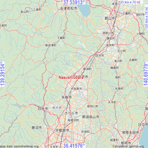
Nasushiobara GPS coordinates[2]
36° 58' 46.272" North, 139° 59' 40.776" East
| Map corner | latitude | longitude |
|---|---|---|
| Upper-left | 37.53913°, | 139.29154° |
| Center: | 36.97952°, | 139.99466° |
| Lower-right: | 36.41576°, | 140.69779° |
| Map W x H: | 124.9×124.9 km | = 77.6×77.6mi |
| max Lat: | 45.40944° ⇑18.1% North |
| Nasushiobara: | 36.97952° |
| min Lat: | ⇓81.9% South 24.34478° |
| min Long | Nasushiobara | max Long |
| 123° | 139.99466° | 145.575° |
| W 78.4%⇐ | ⇒21.6% E |
Elevation
Elevation of Nasushiobara is 357 m = 1171 ft, and this is 272.4 m = 894 ft above average elevation for this country.
| Max E: |
1086 m = 3563 ft | 5.1% |
| Nasushiobara | 357 m 1171 ft | |
| Avg. | 84.6 m = 278 ft | |
Min E: |
-2 m = -7 ft | 94.9% |
See also: Japan elevation on elevation.city.
Geographical zone
Nasushiobara is located in North temperate zone (between Tropic of Cancer and the Arctic Circle). Distance of this Northern Tropic circle is 1505.8 km =935.7 mi to South.| Distance of | km | miles | from Nasushiobara |
|---|---|---|---|
| North Pole | 5895.3 | 3663.2 | to North |
| Arctic Circle | 3289.4 | 2043.9 | to North |
| Tropic Cancer | 1505.8 | 935.7 | to South |
| Equator | 4111.7 | 2554.9 | to South |


Nearby cities:
15 places around Nasushiobara: (largest is in red/bold)
• Daigo
39.5 km =24.5 mi,  126°
126°
• Imaichi
40.3 km =25 mi,  223°
223°
• Ishikawa
44.6 km =27.7 mi,  64°
64°
• Kanuma
53.1 km =33 mi,  205°
205°
• Karasuyama
39.2 km =24.4 mi,  159°
159°
• Kuroiso
5.1 km =3.2 mi,  106°
106°
• Nasukarasuyama
39.3 km =24.4 mi, 157°
• Nikkō
42.2 km =26.2 mi,  232°
232°
• Sakura
28.8 km =17.9 mi,  181°
181°
• Shirakawa
28.4 km =17.6 mi, 56°
• Sukagawa
48.3 km =30 mi,  45°
45°
• Ujiie
33 km =20.5 mi, 184°
• Utsunomiya
47 km =29.2 mi,  192°
192°
• Yaita
20.7 km =12.9 mi,  195°
195°
• Ōtawara
13 km =8.1 mi, 164°
Sources, notices
• [Note1] Compared only with cities in Japan existing in our database
• [Src1] Map data: © OpenStreetMap contributors (CC-BY-SA)
• [Src2] Other city data from geonames.org with taken over terms of usage.
• [Src3] Geographical zone / Annual Mean Temperature by Robert A. Rohde @ Wikipedia
