Otofuke geodata
Otofuke (Hokkaido) is a populated place; located in Japan in Asia/Tokyo (GMT+9) time zone. With population of 40,944 people, there are 442 cities with bigger population in this country. Compared to other cities in Japan, 97% of cities are located further ↓South; 99.2% of cities are located further ←West and 67.4% of cities have lower elevation than Otofuke. Note1


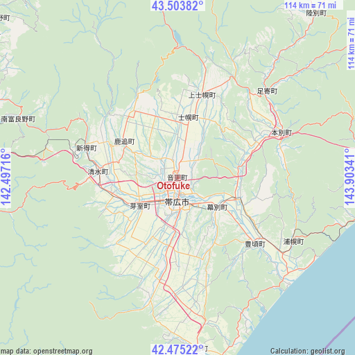
Otofuke GPS coordinates[2]
42° 59' 30.012" North, 143° 12' 1.008" East
| Map corner | latitude | longitude |
|---|---|---|
| Upper-left | 43.50382°, | 142.49716° |
| Center: | 42.99167°, | 143.20028° |
| Lower-right: | 42.47522°, | 143.90341° |
| Map W x H: | 114.4×114.4 km | = 71.1×71.1mi |
| max Lat: | 45.40944° ⇑3% North |
| Otofuke: | 42.99167° |
| min Lat: | ⇓97% South 24.34478° |
| min Long | Otofuke | max Long |
| 123° | 143.20028° | 145.575° |
| W 99.2%⇐ | ⇒0.8% E |
Elevation
Elevation of Otofuke is 64 m = 210 ft, and this is 20.6 m = 68 ft below average elevation for this country.
| Max E: |
1086 m = 3563 ft | 32.6% |
| Avg. | 84.6 m = 278 ft | |
| Otofuke | 64 m = 210 ft | |
Min E: |
-2 m = -7 ft | 67.4% |
See also: Otofuke elevation on elevation.city.
Geographical zone
Otofuke is located in North temperate zone (between Tropic of Cancer and the Arctic Circle). Distance of this Northern Tropic circle is 2174.3 km =1351 mi to South.| Distance of | km | miles | from Otofuke |
|---|---|---|---|
| North Pole | 5226.8 | 3247.8 | to North |
| Arctic Circle | 2620.9 | 1628.6 | to North |
| Tropic Cancer | 2174.3 | 1351 | to South |
| Equator | 4780.2 | 2970.3 | to South |


Nearby cities:
15 places around Otofuke: (largest is in red/bold)
• Akabira
111.8 km =69.5 mi,  303°
303°
• Asahikawa
109.8 km =68.2 mi,  322°
322°
• Ashibetsu
100.4 km =62.4 mi,  305°
305°
• Bibai
114.9 km =71.4 mi,  288°
288°
• Furano
77.3 km =48 mi, 301°
• Kamikawa
100.5 km =62.4 mi,  339°
339°
• Kitami
106.1 km =65.9 mi,  31°
31°
• Kushiro
95.5 km =59.3 mi,  91°
91°
• Mikasa
110.5 km =68.7 mi, 285°
• Motomachi
117.7 km =73.1 mi,  37°
37°
• Obihiro
8.3 km =5.2 mi,  177°
177°
• Shimo-furano
77.3 km =48 mi, 301°
• Shizunai-furukawachō
100 km =62.1 mi,  222°
222°
• Utashinai
109.9 km =68.3 mi, 302°
• Yūbari
101.1 km =62.8 mi,  272°
272°
Sources, notices
• [Note1] Compared only with cities in Japan existing in our database
• [Src1] Map data: © OpenStreetMap contributors (CC-BY-SA)
• [Src2] Other city data from geonames.org with taken over terms of usage.
• [Src3] Geographical zone / Annual Mean Temperature by Robert A. Rohde @ Wikipedia
