Motomachi geodata
Motomachi (Hokkaido) is a populated place; located in Japan in Asia/Tokyo (GMT+9) time zone. With population of 22,972 people, there are 643 cities with bigger population in this country. Compared to other cities in Japan, 99.1% of cities are located further ↓South; 99.6% of cities are located further ←West and 52.3% of cities have higher elevation than Motomachi. Note1


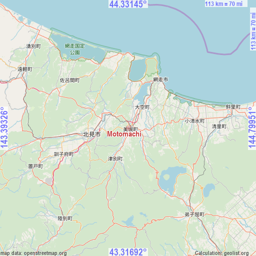
Motomachi GPS coordinates[2]
43° 49' 34.824" North, 144° 5' 46.968" East
| Map corner | latitude | longitude |
|---|---|---|
| Upper-left | 44.33145°, | 143.39326° |
| Center: | 43.82634°, | 144.09638° |
| Lower-right: | 43.31692°, | 144.79951° |
| Map W x H: | 112.8×112.8 km | = 70.1×70.1mi |
| max Lat: | 45.40944° ⇑0.9% North |
| Motomachi: | 43.82634° |
| min Lat: | ⇓99.1% South 24.34478° |
| min Long | Motomachi | max Long |
| 123° | 144.09638° | 145.575° |
| W 99.6%⇐ | ⇒0.40000000000001% E |
Elevation
Elevation of Motomachi is 26 m = 85 ft, and this is 58.6 m = 192 ft below average elevation for this country.
| Max E: |
1086 m = 3563 ft | 52.3% |
| Avg. | 84.6 m = 278 ft | |
| Motomachi | 26 m = 85 ft | |
Min E: |
-2 m = -7 ft | 47.7% |
See also: Japan elevation on elevation.city.
Geographical zone
Motomachi is located in North temperate zone (between Tropic of Cancer and the Arctic Circle). Distance of this Northern Tropic circle is 2267.1 km =1408.7 mi to South.| Distance of | km | miles | from Motomachi |
|---|---|---|---|
| North Pole | 5134 | 3190.1 | to North |
| Arctic Circle | 2528.1 | 1570.9 | to North |
| Tropic Cancer | 2267.1 | 1408.7 | to South |
| Equator | 4873 | 3027.9 | to South |


Nearby cities:
15 places around Motomachi: (largest is in red/bold)
• Abashiri
25.7 km =16 mi,  32°
32°
• Asahikawa
139.1 km =86.4 mi,  267°
267°
• Furano
147.8 km =91.8 mi,  248°
248°
• Kamikawa
106.3 km =66.1 mi, 270°
• Kitami
16.7 km =10.4 mi,  261°
261°
• Kushiro
97.3 km =60.5 mi,  166°
166°
• Mobetsu
76.8 km =47.7 mi,  310°
310°
• Mombetsu
83.4 km =51.8 mi, 314°
• Nayoro
143.3 km =89 mi,  294°
294°
• Nemuro
131.6 km =81.8 mi,  115°
115°
• Obihiro
124.2 km =77.2 mi,  215°
215°
• Otofuke
117.7 km =73.1 mi, 217°
• Shibetsu
85.2 km =52.9 mi,  102°
102°
• Shibetsu
141.4 km =87.9 mi, 285°
• Shimo-furano
147.8 km =91.8 mi, 248°
Sources, notices
• [Note1] Compared only with cities in Japan existing in our database
• [Src1] Map data: © OpenStreetMap contributors (CC-BY-SA)
• [Src2] Other city data from geonames.org with taken over terms of usage.
• [Src3] Geographical zone / Annual Mean Temperature by Robert A. Rohde @ Wikipedia
