Kitami geodata
Kitami (Hokkaido) is a seat of a second-order administrative division; located in Japan in Asia/Tokyo (GMT+9) time zone. With population of 113,137 people, there are 185 cities with bigger population in this country. Compared to other cities in Japan, 99% of cities are located further ↓South; 99.5% of cities are located further ←West and 71.7% of cities have lower elevation than Kitami. Note1


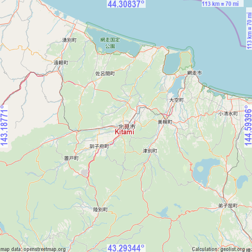
Kitami GPS coordinates[2]
43° 48' 11.016" North, 143° 53' 26.988" East
| Map corner | latitude | longitude |
|---|---|---|
| Upper-left | 44.30837°, | 143.18771° |
| Center: | 43.80306°, | 143.89083° |
| Lower-right: | 43.29344°, | 144.59396° |
| Map W x H: | 112.8×112.8 km | = 70.1×70.1mi |
| max Lat: | 45.40944° ⇑1% North |
| Kitami: | 43.80306° |
| min Lat: | ⇓99% South 24.34478° |
| min Long | Kitami | max Long |
| 123° | 143.89083° | 145.575° |
| W 99.5%⇐ | ⇒0.5% E |
Elevation
Elevation of Kitami is 79 m = 259 ft, and this is 5.6 m = 18 ft below average elevation for this country.
| Max E: |
1086 m = 3563 ft | 28.3% |
| Avg. | 84.6 m = 278 ft | |
| Kitami | 79 m = 259 ft | |
Min E: |
-2 m = -7 ft | 71.7% |
See also: Kitami elevation on elevation.city.
Geographical zone
Kitami is located in North temperate zone (between Tropic of Cancer and the Arctic Circle). Distance of this Northern Tropic circle is 2264.5 km =1407.1 mi to South.| Distance of | km | miles | from Kitami |
|---|---|---|---|
| North Pole | 5136.6 | 3191.7 | to North |
| Arctic Circle | 2530.7 | 1572.5 | to North |
| Tropic Cancer | 2264.5 | 1407.1 | to South |
| Equator | 4870.4 | 3026.3 | to South |


Nearby cities:
15 places around Kitami: (largest is in red/bold)
• Abashiri
38.9 km =24.2 mi,  51°
51°
• Asahikawa
122.5 km =76.1 mi,  268°
268°
• Ashibetsu
141 km =87.6 mi,  256°
256°
• Furano
131.5 km =81.7 mi,  247°
247°
• Kamikawa
89.9 km =55.9 mi, 272°
• Kushiro
100 km =62.1 mi,  156°
156°
• Mobetsu
67.1 km =41.7 mi,  320°
320°
• Mombetsu
74.7 km =46.4 mi, 324°
• Motomachi
16.7 km =10.4 mi,  81°
81°
• Nayoro
129.6 km =80.5 mi,  298°
298°
• Obihiro
113 km =70.2 mi,  209°
209°
• Otofuke
106.1 km =65.9 mi, 211°
• Shibetsu
101 km =62.8 mi,  99°
99°
• Shibetsu
126.5 km =78.6 mi,  288°
288°
• Shimo-furano
131.5 km =81.7 mi, 247°
Sources, notices
• [Note1] Compared only with cities in Japan existing in our database
• [Src1] Map data: © OpenStreetMap contributors (CC-BY-SA)
• [Src2] Other city data from geonames.org with taken over terms of usage.
• [Src3] Geographical zone / Annual Mean Temperature by Robert A. Rohde @ Wikipedia
