Honchō geodata
Honchō (Hokkaido) is a populated place; located in Japan in Asia/Tokyo (GMT+9) time zone. With population of 30,008 people, there are 548 cities with bigger population in this country. Compared to other cities in Japan, 95.7% of cities are located further ↓South; 90% of cities are located further ←West and 72.2% of cities have lower elevation than Honchō. Note1


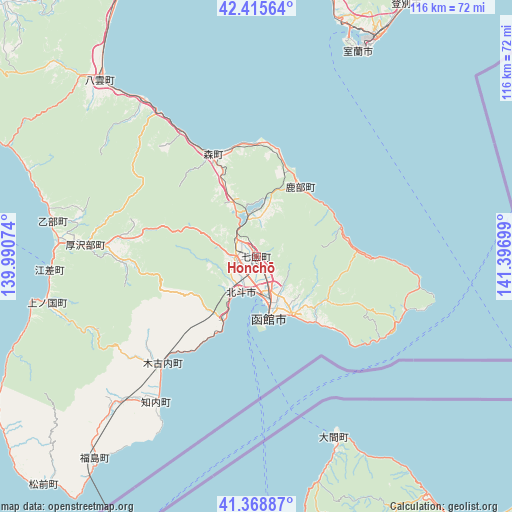
Honchō GPS coordinates[2]
41° 53' 39.84" North, 140° 41' 37.896" East
| Map corner | latitude | longitude |
|---|---|---|
| Upper-left | 42.41564°, | 139.99074° |
| Center: | 41.8944°, | 140.69386° |
| Lower-right: | 41.36887°, | 141.39699° |
| Map W x H: | 116.4×116.4 km | = 72.3×72.3mi |
| max Lat: | 45.40944° ⇑4.3% North |
| Honchō: | 41.8944° |
| min Lat: | ⇓95.7% South 24.34478° |
| min Long | Honchō | max Long |
| 123° | 140.69386° | 145.575° |
| W 90%⇐ | ⇒10% E |
Elevation
Elevation of Honchō is 81 m = 266 ft, and this is 3.6 m = 12 ft below average elevation for this country.
| Max E: |
1086 m = 3563 ft | 27.8% |
| Avg. | 84.6 m = 278 ft | |
| Honchō | 81 m = 266 ft | |
Min E: |
-2 m = -7 ft | 72.2% |
See also: Japan elevation on elevation.city.
Geographical zone
Honchō is located in North temperate zone (between Tropic of Cancer and the Arctic Circle). Distance of this Northern Tropic circle is 2052.3 km =1275.2 mi to South.| Distance of | km | miles | from Honchō |
|---|---|---|---|
| North Pole | 5348.8 | 3323.6 | to North |
| Arctic Circle | 2743 | 1704.4 | to North |
| Tropic Cancer | 2052.3 | 1275.2 | to South |
| Equator | 4658.2 | 2894.5 | to South |


Nearby cities:
15 places around Honchō: (largest is in red/bold)
• Aomori
119.9 km =74.5 mi,  178°
178°
• Date
65.4 km =40.6 mi,  12°
12°
• Goshogawara
123 km =76.4 mi,  189°
189°
• Hakodate
13.7 km =8.5 mi,  164°
164°
• Hokuto
10 km =6.2 mi,  209°
209°
• Iwanai
121 km =75.2 mi,  352°
352°
• Kamiiso
9.2 km =5.7 mi, 206°
• Muroran
52.9 km =32.9 mi,  27°
27°
• Mutsu
80.1 km =49.8 mi,  147°
147°
• Niseko Town
98.3 km =61.1 mi,  358°
358°
• Noboribetsu
73.8 km =45.9 mi, 32°
• Shimokizukuri
122.8 km =76.3 mi, 192°
• Shiraoi
90.7 km =56.4 mi,  36°
36°
• Tomakomai
111.4 km =69.2 mi, 42°
• Tsugaru
123.7 km =76.9 mi, 191°
Sources, notices
• [Note1] Compared only with cities in Japan existing in our database
• [Src1] Map data: © OpenStreetMap contributors (CC-BY-SA)
• [Src2] Other city data from geonames.org with taken over terms of usage.
• [Src3] Geographical zone / Annual Mean Temperature by Robert A. Rohde @ Wikipedia
