Hakodate geodata
Hakodate (Hokkaido) is a seat of a second-order administrative division; located in Japan in Asia/Tokyo (GMT+9) time zone. With population of 275,730 people, there are 74 cities with bigger population in this country. Compared to other cities in Japan, 95.4% of cities are located further ↓South; 90.5% of cities are located further ←West and 89.6% of cities have higher elevation than Hakodate. Note1


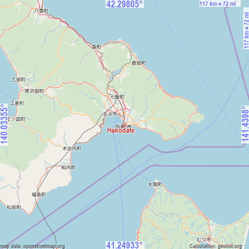
Hakodate GPS coordinates[2]
41° 46' 32.988" North, 140° 44' 12.012" East
| Map corner | latitude | longitude |
|---|---|---|
| Upper-left | 42.29805°, | 140.03355° |
| Center: | 41.77583°, | 140.73667° |
| Lower-right: | 41.24933°, | 141.4398° |
| Map W x H: | 116.6×116.6 km | = 72.5×72.5mi |
| max Lat: | 45.40944° ⇑4.6% North |
| Hakodate: | 41.77583° |
| min Lat: | ⇓95.4% South 24.34478° |
| min Long | Hakodate | max Long |
| 123° | 140.73667° | 145.575° |
| W 90.5%⇐ | ⇒9.5% E |
Elevation
Elevation of Hakodate is 5 m = 16 ft, and this is 79.6 m = 261 ft below average elevation for this country.
| Max E: |
1086 m = 3563 ft | 89.6% |
| Avg. | 84.6 m = 278 ft | |
| Hakodate | 5 m = 16 ft | |
Min E: |
-2 m = -7 ft | 10.4% |
See also: Hakodate elevation on elevation.city.
Geographical zone
Hakodate is located in North temperate zone (between Tropic of Cancer and the Arctic Circle). Distance of this Northern Tropic circle is 2039.1 km =1267 mi to South.| Distance of | km | miles | from Hakodate |
|---|---|---|---|
| North Pole | 5362 | 3331.8 | to North |
| Arctic Circle | 2756.1 | 1712.6 | to North |
| Tropic Cancer | 2039.1 | 1267 | to South |
| Equator | 4645 | 2886.3 | to South |


Nearby cities:
15 places around Hakodate: (largest is in red/bold)
• Aomori
106.6 km =66.2 mi,  180°
180°
• Date
77.7 km =48.3 mi,  8°
8°
• Goshogawara
110.8 km =68.8 mi,  192°
192°
• Hokuto
9.6 km =6 mi,  298°
298°
• Honchō
13.7 km =8.5 mi,  344°
344°
• Kamiiso
9.1 km =5.7 mi, 302°
• Muroran
63.7 km =39.6 mi,  19°
19°
• Mutsu
67.3 km =41.8 mi,  143°
143°
• Namioka
119.1 km =74 mi, 185°
• Niseko Town
111.6 km =69.3 mi,  357°
357°
• Noboribetsu
83.6 km =51.9 mi,  25°
25°
• Shimokizukuri
110.9 km =68.9 mi,  195°
195°
• Shiraoi
99.8 km =62 mi, 30°
• Tomakomai
119.4 km =74.2 mi,  36°
36°
• Tsugaru
111.6 km =69.3 mi, 194°
Sources, notices
• [Note1] Compared only with cities in Japan existing in our database
• [Src1] Map data: © OpenStreetMap contributors (CC-BY-SA)
• [Src2] Other city data from geonames.org with taken over terms of usage.
• [Src3] Geographical zone / Annual Mean Temperature by Robert A. Rohde @ Wikipedia
