Satte geodata
Satte (Saitama) is a seat of a second-order administrative division; located in Japan in Asia/Tokyo (GMT+9) time zone. With population of 55,286 people, there are 350 cities with bigger population in this country. Compared to other cities in Japan, 69.4% of cities are located further ↓South; 73.8% of cities are located further ←West and 76.3% of cities have higher elevation than Satte. Note1


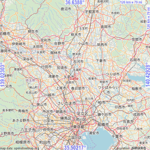
Satte GPS coordinates[2]
36° 4' 21.144" North, 139° 43' 34.14" East
| Map corner | latitude | longitude |
|---|---|---|
| Upper-left | 36.6388°, | 139.02303° |
| Center: | 36.07254°, | 139.72615° |
| Lower-right: | 35.50217°, | 140.42928° |
| Map W x H: | 126.4×126.4 km | = 78.5×78.5mi |
| max Lat: | 45.40944° ⇑30.6% North |
| Satte: | 36.07254° |
| min Lat: | ⇓69.4% South 24.34478° |
| min Long | Satte | max Long |
| 123° | 139.72615° | 145.575° |
| W 73.8%⇐ | ⇒26.2% E |
Elevation
Elevation of Satte is 9 m = 30 ft, and this is 75.6 m = 248 ft below average elevation for this country.
| Max E: |
1086 m = 3563 ft | 76.3% |
| Avg. | 84.6 m = 278 ft | |
| Satte | 9 m = 30 ft | |
Min E: |
-2 m = -7 ft | 23.7% |
See also: Satte elevation on elevation.city.
Geographical zone
Satte is located in North temperate zone (between Tropic of Cancer and the Arctic Circle). Distance of this Northern Tropic circle is 1405 km =873 mi to South.| Distance of | km | miles | from Satte |
|---|---|---|---|
| North Pole | 5996.2 | 3725.9 | to North |
| Arctic Circle | 3390.3 | 2106.6 | to North |
| Tropic Cancer | 1405 | 873 | to South |
| Equator | 4010.9 | 2492.3 | to South |


Nearby cities:
15 places around Satte: (largest is in red/bold)
• Ageoshimo
15.1 km =9.4 mi,  221°
221°
• Bandō
12.7 km =7.9 mi,  91°
91°
• Hasuda
13.2 km =8.2 mi,  211°
211°
• Iwai
15.8 km =9.8 mi,  99°
99°
• Iwatsuki
12.3 km =7.6 mi,  192°
192°
• Kasukabe
10.2 km =6.3 mi,  168°
168°
• Kazo
12.4 km =7.7 mi,  293°
293°
• Kisai
13.2 km =8.2 mi,  283°
283°
• Koga
12.3 km =7.6 mi,  356°
356°
• Kukichūō
4.6 km =2.9 mi,  262°
262°
• Kurihashi
7.2 km =4.5 mi,  340°
340°
• Sakai
7.3 km =4.5 mi,  65°
65°
• Shiraoka
8.4 km =5.2 mi, 224°
• Shōbu
11.4 km =7.1 mi,  266°
266°
• Sugito
4.6 km =2.9 mi,  179°
179°
Sources, notices
• [Note1] Compared only with cities in Japan existing in our database
• [Src1] Map data: © OpenStreetMap contributors (CC-BY-SA)
• [Src2] Other city data from geonames.org with taken over terms of usage.
• [Src3] Geographical zone / Annual Mean Temperature by Robert A. Rohde @ Wikipedia
