Sugito geodata
Sugito (Saitama) is a populated place; located in Japan in Asia/Tokyo (GMT+9) time zone. With population of 49,817 people, there are 377 cities with bigger population in this country. Compared to other cities in Japan, 67.9% of cities are located further ↓South; 73.9% of cities are located further ←West and 73.6% of cities have higher elevation than Sugito. Note1


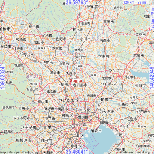
Sugito GPS coordinates[2]
36° 1' 51.852" North, 139° 43' 34.896" East
| Map corner | latitude | longitude |
|---|---|---|
| Upper-left | 36.59763°, | 139.02324° |
| Center: | 36.03107°, | 139.72636° |
| Lower-right: | 35.46041°, | 140.42949° |
| Map W x H: | 126.4×126.4 km | = 78.5×78.5mi |
| max Lat: | 45.40944° ⇑32.1% North |
| Sugito: | 36.03107° |
| min Lat: | ⇓67.9% South 24.34478° |
| min Long | Sugito | max Long |
| 123° | 139.72636° | 145.575° |
| W 73.9%⇐ | ⇒26.1% E |
Elevation
Elevation of Sugito is 10 m = 33 ft, and this is 74.6 m = 245 ft below average elevation for this country.
| Max E: |
1086 m = 3563 ft | 73.6% |
| Avg. | 84.6 m = 278 ft | |
| Sugito | 10 m = 33 ft | |
Min E: |
-2 m = -7 ft | 26.4% |
See also: Sugito elevation on elevation.city.
Geographical zone
Sugito is located in North temperate zone (between Tropic of Cancer and the Arctic Circle). Distance of this Northern Tropic circle is 1400.4 km =870.2 mi to South.| Distance of | km | miles | from Sugito |
|---|---|---|---|
| North Pole | 6000.8 | 3728.7 | to North |
| Arctic Circle | 3394.9 | 2109.5 | to North |
| Tropic Cancer | 1400.4 | 870.2 | to South |
| Equator | 4006.3 | 2489.4 | to South |


Nearby cities:
15 places around Sugito: (largest is in red/bold)
• Ageoshimo
12.1 km =7.5 mi,  236°
236°
• Bandō
13.4 km =8.3 mi,  71°
71°
• Hasuda
9.6 km =6 mi,  226°
226°
• Iwatsuki
7.9 km =4.9 mi,  200°
200°
• Kasukabe
5.7 km =3.5 mi,  158°
158°
• Kazo
14.8 km =9.2 mi,  309°
309°
• Kisai
15 km =9.3 mi,  300°
300°
• Kukichūō
6.1 km =3.8 mi, 311°
• Kurihashi
11.6 km =7.2 mi,  348°
348°
• Okegawa
15.6 km =9.7 mi,  257°
257°
• Saitama
15 km =9.3 mi, 204°
• Sakai
10.1 km =6.3 mi,  40°
40°
• Satte
4.6 km =2.9 mi,  359°
359°
• Shiraoka
6.1 km =3.8 mi, 256°
• Shōbu
12 km =7.5 mi,  289°
289°
Sources, notices
• [Note1] Compared only with cities in Japan existing in our database
• [Src1] Map data: © OpenStreetMap contributors (CC-BY-SA)
• [Src2] Other city data from geonames.org with taken over terms of usage.
• [Src3] Geographical zone / Annual Mean Temperature by Robert A. Rohde @ Wikipedia
