Sakurai geodata
Sakurai (Nara) is a seat of a second-order administrative division; located in Japan in Asia/Tokyo (GMT+9) time zone. With population of 62,964 people, there are 311 cities with bigger population in this country. Compared to other cities in Japan, 72.6% of cities are located further ↑North; 62.4% of cities are located further →East and 78% of cities have lower elevation than Sakurai. Note1


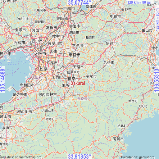
Sakurai GPS coordinates[2]
34° 30' 0" North, 135° 51' 0" East
| Map corner | latitude | longitude |
|---|---|---|
| Upper-left | 35.07744°, | 135.14688° |
| Center: | 34.5°, | 135.85° |
| Lower-right: | 33.91853°, | 136.55313° |
| Map W x H: | 128.9×128.9 km | = 80.1×80.1mi |
| max Lat: | 45.40944° ⇑72.6% North |
| Sakurai: | 34.5° |
| min Lat: | ⇓27.4% South 24.34478° |
| min Long | Sakurai | max Long |
| 123° | 135.85° | 145.575° |
| W 37.6%⇐ | ⇒62.4% E |
Elevation
Elevation of Sakurai is 108 m = 354 ft, and this is 23.4 m = 77 ft above average elevation for this country.
| Max E: |
1086 m = 3563 ft | 22% |
| Sakurai | 108 m 354 ft | |
| Avg. | 84.6 m = 278 ft | |
Min E: |
-2 m = -7 ft | 78% |
See also: Sakurai elevation on elevation.city.
Geographical zone
Sakurai is located in North temperate zone (between Tropic of Cancer and the Arctic Circle). Distance of this Northern Tropic circle is 1230.1 km =764.3 mi to South.| Distance of | km | miles | from Sakurai |
|---|---|---|---|
| North Pole | 6171 | 3834.5 | to North |
| Arctic Circle | 3565.1 | 2215.2 | to North |
| Tropic Cancer | 1230.1 | 764.3 | to South |
| Equator | 3836 | 2383.6 | to South |


Nearby cities:
15 places around Sakurai: (largest is in red/bold)
• Gojō
21.6 km =13.4 mi,  219°
219°
• Gose
12.1 km =7.5 mi,  242°
242°
• Haibara-akanedai
9.9 km =6.2 mi,  67°
67°
• Hōryūji
16.2 km =10.1 mi,  320°
320°
• Kashiba
13.5 km =8.4 mi,  286°
286°
• Kashihara-shi
5.3 km =3.3 mi,  280°
280°
• Katsuragi
14.1 km =8.8 mi,  263°
263°
• Nara-shi
21 km =13 mi,  348°
348°
• Tawaramoto
8 km =5 mi, 319°
• Tenri
9.4 km =5.8 mi, 350°
• Tondabayashichō
22.7 km =14.1 mi,  270°
270°
• Yamato-Takada
9.3 km =5.8 mi, 281°
• Yamatokōriyama
13.9 km =8.6 mi,  328°
328°
• Yoshino-chō
11.6 km =7.2 mi,  176°
176°
• Ōuda
8.5 km =5.3 mi,  115°
115°
Sources, notices
• [Note1] Compared only with cities in Japan existing in our database
• [Src1] Map data: © OpenStreetMap contributors (CC-BY-SA)
• [Src2] Other city data from geonames.org with taken over terms of usage.
• [Src3] Geographical zone / Annual Mean Temperature by Robert A. Rohde @ Wikipedia
