Yonedacho Sendo geodata
Yonedacho Sendo (Hyōgo) is a section of populated place; located in Japan in Asia/Tokyo (GMT+9) time zone. With population of 6,000 people, there are 751 cities with bigger population in this country. Compared to other cities in Japan, 65.7% of cities are located further ↑North; 71.6% of cities are located further →East and 86% of cities have higher elevation than Yonedacho Sendo. Note1


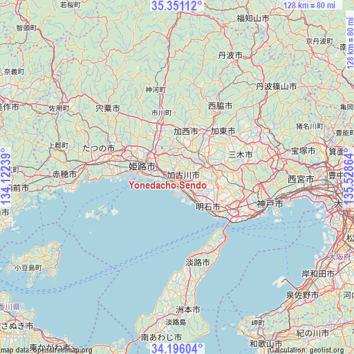
Yonedacho Sendo GPS coordinates[2]
34° 46' 32.16" North, 134° 49' 31.836" East
| Map corner | latitude | longitude |
|---|---|---|
| Upper-left | 35.35112°, | 134.12239° |
| Center: | 34.7756°, | 134.82551° |
| Lower-right: | 34.19604°, | 135.52864° |
| Map W x H: | 128.4×128.4 km | = 79.8×79.8mi |
| max Lat: | 45.40944° ⇑65.7% North |
| Yonedacho Sendo: | 34.7756° |
| min Lat: | ⇓34.3% South 24.34478° |
| min Long | Yonedacho Sendo | max Long |
| 123° | 134.82551° | 145.575° |
| W 28.4%⇐ | ⇒71.6% E |
Elevation
Elevation of Yonedacho Sendo is 6 m = 20 ft, and this is 78.6 m = 258 ft below average elevation for this country.
| Max E: |
1086 m = 3563 ft | 86% |
| Avg. | 84.6 m = 278 ft | |
| Yonedacho Sendo | 6 m = 20 ft | |
Min E: |
-2 m = -7 ft | 14% |
See also: Japan elevation on elevation.city.
Geographical zone
Yonedacho Sendo is located in North temperate zone (between Tropic of Cancer and the Arctic Circle). Distance of this Northern Tropic circle is 1260.8 km =783.4 mi to South.| Distance of | km | miles | from Yonedacho Sendo |
|---|---|---|---|
| North Pole | 6140.4 | 3815.5 | to North |
| Arctic Circle | 3534.5 | 2196.2 | to North |
| Tropic Cancer | 1260.8 | 783.4 | to South |
| Equator | 3866.7 | 2402.7 | to South |


Nearby cities:
15 places around Yonedacho Sendo: (largest is in red/bold)
• Aioi
32.8 km =20.4 mi,  275°
275°
• Akashi
21.3 km =13.2 mi,  128°
128°
• Himeji
12.3 km =7.6 mi,  291°
291°
• Kakogawa
4.9 km =3 mi,  124°
124°
• Kakogawachō-honmachi
0.8 km =0.5 mi,  154°
154°
• Kasai
16.9 km =10.5 mi,  6°
6°
• Katō
24.7 km =15.3 mi,  47°
47°
• Miki
14.7 km =9.1 mi,  79°
79°
• Nishiwaki
26.9 km =16.7 mi,  30°
30°
• Ono
12.9 km =8 mi, 49°
• Shirahamachō-usazakiminami
10 km =6.2 mi,  274°
274°
• Takasago
3.3 km =2.1 mi,  245°
245°
• Tatsuno
26.5 km =16.5 mi, 283°
• Tatsunochō-tominaga
26.8 km =16.7 mi, 291°
• Yashiro
20.3 km =12.6 mi,  39°
39°
Sources, notices
• [Note1] Compared only with cities in Japan existing in our database
• [Src1] Map data: © OpenStreetMap contributors (CC-BY-SA)
• [Src2] Other city data from geonames.org with taken over terms of usage.
• [Src3] Geographical zone / Annual Mean Temperature by Robert A. Rohde @ Wikipedia
