Kakogawa geodata
Kakogawa (Hyōgo) is a seat of a second-order administrative division; located in Japan in Asia/Tokyo (GMT+9) time zone. In our database, there are 767 cities with bigger population. Compared to other cities in Japan, 66.9% of cities are located further ↑North; 71.3% of cities are located further →East and 60.4% of cities have higher elevation than Kakogawa. Note1


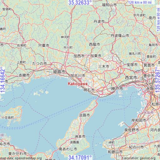
Kakogawa GPS coordinates[2]
34° 45' 2.304" North, 134° 52' 10.344" East
| Map corner | latitude | longitude |
|---|---|---|
| Upper-left | 35.32633°, | 134.16642° |
| Center: | 34.75064°, | 134.86954° |
| Lower-right: | 34.17091°, | 135.57267° |
| Map W x H: | 128.5×128.5 km | = 79.8×79.8mi |
| max Lat: | 45.40944° ⇑66.9% North |
| Kakogawa: | 34.75064° |
| min Lat: | ⇓33.1% South 24.34478° |
| min Long | Kakogawa | max Long |
| 123° | 134.86954° | 145.575° |
| W 28.7%⇐ | ⇒71.3% E |
Elevation
Elevation of Kakogawa is 19 m = 62 ft, and this is 65.6 m = 215 ft below average elevation for this country.
| Max E: |
1086 m = 3563 ft | 60.4% |
| Avg. | 84.6 m = 278 ft | |
| Kakogawa | 19 m = 62 ft | |
Min E: |
-2 m = -7 ft | 39.6% |
See also: Japan elevation on elevation.city.
Geographical zone
Kakogawa is located in North temperate zone (between Tropic of Cancer and the Arctic Circle). Distance of this Northern Tropic circle is 1258 km =781.7 mi to South.| Distance of | km | miles | from Kakogawa |
|---|---|---|---|
| North Pole | 6143.2 | 3817.2 | to North |
| Arctic Circle | 3537.3 | 2198 | to North |
| Tropic Cancer | 1258 | 781.7 | to South |
| Equator | 3863.9 | 2400.9 | to South |


Nearby cities:
15 places around Kakogawa: (largest is in red/bold)
• Akashi
16.4 km =10.2 mi,  130°
130°
• Awaji
30.9 km =19.2 mi,  169°
169°
• Himeji
17.1 km =10.6 mi,  295°
295°
• Kakogawachō-honmachi
4.2 km =2.6 mi, 299°
• Kasai
19.7 km =12.2 mi,  353°
353°
• Katō
24 km =14.9 mi,  36°
36°
• Kobe
29.4 km =18.3 mi,  102°
102°
• Miki
11.8 km =7.3 mi,  62°
62°
• Nishiwaki
27.7 km =17.2 mi,  20°
20°
• Ono
12.5 km =7.8 mi,  27°
27°
• Shirahamachō-usazakiminami
14.4 km =8.9 mi,  284°
284°
• Takasago
7.2 km =4.5 mi, 281°
• Tatsuno
31.1 km =19.3 mi,  286°
286°
• Yashiro
20.5 km =12.7 mi, 25°
• Yonedacho Sendo
4.9 km =3 mi, 304°
Sources, notices
• [Note1] Compared only with cities in Japan existing in our database
• [Src1] Map data: © OpenStreetMap contributors (CC-BY-SA)
• [Src2] Other city data from geonames.org with taken over terms of usage.
• [Src3] Geographical zone / Annual Mean Temperature by Robert A. Rohde @ Wikipedia
