Himeji geodata
Himeji (Hyōgo) is a seat of a second-order administrative division; located in Japan in Asia/Tokyo (GMT+9) time zone. With population of 481,493 people, there are 24 cities with bigger population in this country. Compared to other cities in Japan, 63.9% of cities are located further ↑North; 72.3% of cities are located further →East and 79% of cities have higher elevation than Himeji. Note1


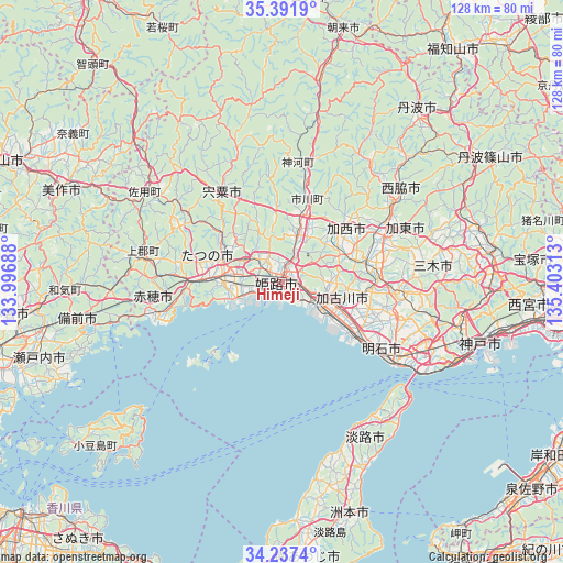
Himeji GPS coordinates[2]
34° 49' 0.012" North, 134° 42' 0" East
| Map corner | latitude | longitude |
|---|---|---|
| Upper-left | 35.3919°, | 133.99688° |
| Center: | 34.81667°, | 134.7° |
| Lower-right: | 34.2374°, | 135.40313° |
| Map W x H: | 128.4×128.4 km | = 79.8×79.8mi |
| max Lat: | 45.40944° ⇑63.9% North |
| Himeji: | 34.81667° |
| min Lat: | ⇓36.1% South 24.34478° |
| min Long | Himeji | max Long |
| 123° | 134.7° | 145.575° |
| W 27.7%⇐ | ⇒72.3% E |
Elevation
Elevation of Himeji is 8 m = 26 ft, and this is 76.6 m = 251 ft below average elevation for this country.
| Max E: |
1086 m = 3563 ft | 79% |
| Avg. | 84.6 m = 278 ft | |
| Himeji | 8 m = 26 ft | |
Min E: |
-2 m = -7 ft | 21% |
See also: Himeji elevation on elevation.city.
Geographical zone
Himeji is located in North temperate zone (between Tropic of Cancer and the Arctic Circle). Distance of this Northern Tropic circle is 1265.3 km =786.2 mi to South.| Distance of | km | miles | from Himeji |
|---|---|---|---|
| North Pole | 6135.8 | 3812.6 | to North |
| Arctic Circle | 3529.9 | 2193.4 | to North |
| Tropic Cancer | 1265.3 | 786.2 | to South |
| Equator | 3871.3 | 2405.5 | to South |


Nearby cities:
15 places around Himeji: (largest is in red/bold)
• Aioi
21.2 km =13.2 mi,  266°
266°
• Kakogawa
17.1 km =10.6 mi,  115°
115°
• Kakogawachō-honmachi
12.9 km =8 mi,  114°
114°
• Kariya
29.5 km =18.3 mi,  255°
255°
• Kasai
18 km =11.2 mi,  47°
47°
• Miki
25.9 km =16.1 mi,  94°
94°
• Ono
21.6 km =13.4 mi,  80°
80°
• Shirahamachō-usazakiminami
4 km =2.5 mi,  157°
157°
• Shisō
22.1 km =13.7 mi,  325°
325°
• Takasago
10.3 km =6.4 mi,  125°
125°
• Tatsuno
14.4 km =8.9 mi,  276°
276°
• Tatsunochō-tominaga
14.5 km =9 mi,  291°
291°
• Yamazakichō-nakabirose
24.5 km =15.2 mi, 326°
• Yashiro
26.7 km =16.6 mi,  65°
65°
• Yonedacho Sendo
12.3 km =7.6 mi, 111°
Sources, notices
• [Note1] Compared only with cities in Japan existing in our database
• [Src1] Map data: © OpenStreetMap contributors (CC-BY-SA)
• [Src2] Other city data from geonames.org with taken over terms of usage.
• [Src3] Geographical zone / Annual Mean Temperature by Robert A. Rohde @ Wikipedia
