Takasago geodata
Takasago (Hyōgo) is a seat of a second-order administrative division; located in Japan in Asia/Tokyo (GMT+9) time zone. In our database, there are 767 cities with bigger population. Compared to other cities in Japan, 66.3% of cities are located further ↑North; 71.8% of cities are located further →East and 96.8% of cities have higher elevation than Takasago. Note1


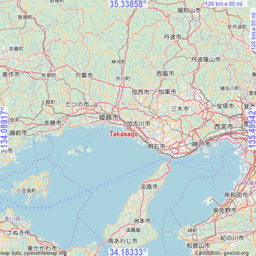
Takasago GPS coordinates[2]
34° 45' 46.728" North, 134° 47' 32.244" East
| Map corner | latitude | longitude |
|---|---|---|
| Upper-left | 35.33858°, | 134.08917° |
| Center: | 34.76298°, | 134.79229° |
| Lower-right: | 34.18333°, | 135.49542° |
| Map W x H: | 128.5×128.5 km | = 79.8×79.8mi |
| max Lat: | 45.40944° ⇑66.3% North |
| Takasago: | 34.76298° |
| min Lat: | ⇓33.7% South 24.34478° |
| min Long | Takasago | max Long |
| 123° | 134.79229° | 145.575° |
| W 28.2%⇐ | ⇒71.8% E |
Elevation
Elevation of Takasago is 2 m = 7 ft, and this is 82.6 m = 271 ft below average elevation for this country.
| Max E: |
1086 m = 3563 ft | 96.8% |
| Avg. | 84.6 m = 278 ft | |
| Takasago | 2 m = 7 ft | |
Min E: |
-2 m = -7 ft | 3.2% |
See also: Japan elevation on elevation.city.
Geographical zone
Takasago is located in North temperate zone (between Tropic of Cancer and the Arctic Circle). Distance of this Northern Tropic circle is 1259.4 km =782.6 mi to South.| Distance of | km | miles | from Takasago |
|---|---|---|---|
| North Pole | 6141.8 | 3816.3 | to North |
| Arctic Circle | 3535.9 | 2197.1 | to North |
| Tropic Cancer | 1259.4 | 782.6 | to South |
| Equator | 3865.3 | 2401.8 | to South |


Nearby cities:
15 places around Takasago: (largest is in red/bold)
• Aioi
30 km =18.6 mi,  278°
278°
• Akashi
23 km =14.3 mi,  121°
121°
• Himeji
10.3 km =6.4 mi,  305°
305°
• Kakogawa
7.2 km =4.5 mi,  101°
101°
• Kakogawachō-honmachi
3.4 km =2.1 mi,  77°
77°
• Kasai
18.8 km =11.7 mi,  14°
14°
• Katō
27.9 km =17.3 mi,  49°
49°
• Miki
17.9 km =11.1 mi, 76°
• Nishiwaki
29.7 km =18.5 mi,  33°
33°
• Ono
16.1 km =10 mi, 53°
• Shirahamachō-usazakiminami
7.3 km =4.5 mi,  288°
288°
• Tatsuno
24 km =14.9 mi, 288°
• Tatsunochō-tominaga
24.7 km =15.3 mi,  297°
297°
• Yashiro
23.4 km =14.5 mi,  42°
42°
• Yonedacho Sendo
3.3 km =2.1 mi,  65°
65°
Sources, notices
• [Note1] Compared only with cities in Japan existing in our database
• [Src1] Map data: © OpenStreetMap contributors (CC-BY-SA)
• [Src2] Other city data from geonames.org with taken over terms of usage.
• [Src3] Geographical zone / Annual Mean Temperature by Robert A. Rohde @ Wikipedia
