Nishiwaki geodata
Nishiwaki (Hyōgo) is a seat of a second-order administrative division; located in Japan in Asia/Tokyo (GMT+9) time zone. With population of 36,953 people, there are 483 cities with bigger population in this country. Compared to other cities in Japan, 59.1% of cities are located further ↑North; 70.8% of cities are located further →East and 65% of cities have lower elevation than Nishiwaki. Note1


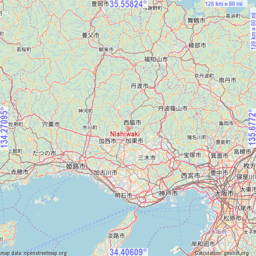
Nishiwaki GPS coordinates[2]
34° 59' 3.084" North, 134° 58' 26.652" East
| Map corner | latitude | longitude |
|---|---|---|
| Upper-left | 35.55824°, | 134.27095° |
| Center: | 34.98419°, | 134.97407° |
| Lower-right: | 34.40609°, | 135.6772° |
| Map W x H: | 128.1×128.1 km | = 79.6×79.6mi |
| max Lat: | 45.40944° ⇑59.1% North |
| Nishiwaki: | 34.98419° |
| min Lat: | ⇓40.9% South 24.34478° |
| min Long | Nishiwaki | max Long |
| 123° | 134.97407° | 145.575° |
| W 29.2%⇐ | ⇒70.8% E |
Elevation
Elevation of Nishiwaki is 57 m = 187 ft, and this is 27.6 m = 91 ft below average elevation for this country.
| Max E: |
1086 m = 3563 ft | 35% |
| Avg. | 84.6 m = 278 ft | |
| Nishiwaki | 57 m = 187 ft | |
Min E: |
-2 m = -7 ft | 65% |
See also: Japan elevation on elevation.city.
Geographical zone
Nishiwaki is located in North temperate zone (between Tropic of Cancer and the Arctic Circle). Distance of this Northern Tropic circle is 1284 km =797.8 mi to South.| Distance of | km | miles | from Nishiwaki |
|---|---|---|---|
| North Pole | 6117.2 | 3801.1 | to North |
| Arctic Circle | 3511.3 | 2181.8 | to North |
| Tropic Cancer | 1284 | 797.8 | to South |
| Equator | 3889.9 | 2417.1 | to South |


Nearby cities:
15 places around Nishiwaki: (largest is in red/bold)
• Himeji
31.2 km =19.4 mi,  233°
233°
• Kakogawa
27.7 km =17.2 mi,  200°
200°
• Kakogawachō-honmachi
27.3 km =17 mi,  208°
208°
• Kasai
13.4 km =8.3 mi,  241°
241°
• Katō
8.2 km =5.1 mi,  144°
144°
• Miki
20.5 km =12.7 mi,  177°
177°
• Ono
15.4 km =9.6 mi,  193°
193°
• Sanda
22.2 km =13.8 mi,  100°
100°
• Sandachō
25.6 km =15.9 mi,  115°
115°
• Sasayama
23.9 km =14.9 mi,  67°
67°
• Shirahamachō-usazakiminami
32.4 km =20.1 mi, 226°
• Takasago
29.7 km =18.5 mi, 213°
• Tanba
20.5 km =12.7 mi,  16°
16°
• Yashiro
7.5 km =4.7 mi, 185°
• Yonedacho Sendo
26.9 km =16.7 mi, 210°
Sources, notices
• [Note1] Compared only with cities in Japan existing in our database
• [Src1] Map data: © OpenStreetMap contributors (CC-BY-SA)
• [Src2] Other city data from geonames.org with taken over terms of usage.
• [Src3] Geographical zone / Annual Mean Temperature by Robert A. Rohde @ Wikipedia
