Yashiro geodata
Yashiro (Hyōgo) is a populated place; located in Japan in Asia/Tokyo (GMT+9) time zone. With population of 21,554 people, there are 671 cities with bigger population in this country. Compared to other cities in Japan, 60.9% of cities are located further ↑North; 70.9% of cities are located further →East and 68.8% of cities have lower elevation than Yashiro. Note1


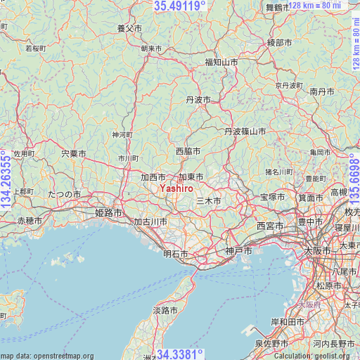
Yashiro GPS coordinates[2]
34° 55' 0.012" North, 134° 58' 0.012" East
| Map corner | latitude | longitude |
|---|---|---|
| Upper-left | 35.49119°, | 134.26355° |
| Center: | 34.91667°, | 134.96667° |
| Lower-right: | 34.3381°, | 135.6698° |
| Map W x H: | 128.2×128.2 km | = 79.7×79.7mi |
| max Lat: | 45.40944° ⇑60.9% North |
| Yashiro: | 34.91667° |
| min Lat: | ⇓39.1% South 24.34478° |
| min Long | Yashiro | max Long |
| 123° | 134.96667° | 145.575° |
| W 29.1%⇐ | ⇒70.9% E |
Elevation
Elevation of Yashiro is 67 m = 220 ft, and this is 17.6 m = 58 ft below average elevation for this country.
| Max E: |
1086 m = 3563 ft | 31.2% |
| Avg. | 84.6 m = 278 ft | |
| Yashiro | 67 m = 220 ft | |
Min E: |
-2 m = -7 ft | 68.8% |
See also: Japan elevation on elevation.city.
Geographical zone
Yashiro is located in North temperate zone (between Tropic of Cancer and the Arctic Circle). Distance of this Northern Tropic circle is 1276.5 km =793.2 mi to South.| Distance of | km | miles | from Yashiro |
|---|---|---|---|
| North Pole | 6124.7 | 3805.7 | to North |
| Arctic Circle | 3518.8 | 2186.5 | to North |
| Tropic Cancer | 1276.5 | 793.2 | to South |
| Equator | 3882.4 | 2412.4 | to South |


Nearby cities:
15 places around Yashiro: (largest is in red/bold)
• Himeji
26.7 km =16.6 mi,  245°
245°
• Kakogawa
20.5 km =12.7 mi,  205°
205°
• Kakogawachō-honmachi
20.6 km =12.8 mi,  217°
217°
• Kasai
11.1 km =6.9 mi,  275°
275°
• Katō
5.5 km =3.4 mi,  81°
81°
• Miki
13.1 km =8.1 mi,  173°
173°
• Nishiwaki
7.5 km =4.7 mi,  5°
5°
• Ono
8 km =5 mi,  202°
202°
• Sanda
22.8 km =14.2 mi, 81°
• Sandachō
24 km =14.9 mi,  98°
98°
• Sasayama
28.2 km =17.5 mi,  53°
53°
• Shirahamachō-usazakiminami
27.2 km =16.9 mi,  236°
236°
• Takasago
23.4 km =14.5 mi, 222°
• Tanba
27.9 km =17.3 mi, 13°
• Yonedacho Sendo
20.3 km =12.6 mi, 219°
Sources, notices
• [Note1] Compared only with cities in Japan existing in our database
• [Src1] Map data: © OpenStreetMap contributors (CC-BY-SA)
• [Src2] Other city data from geonames.org with taken over terms of usage.
• [Src3] Geographical zone / Annual Mean Temperature by Robert A. Rohde @ Wikipedia
