Fujioka geodata
Fujioka (Gunma) is a seat of a second-order administrative division; located in Japan in Asia/Tokyo (GMT+9) time zone. With population of 63,358 people, there are 308 cities with bigger population in this country. Compared to other cities in Japan, 72.3% of cities are located further ↓South; 61.5% of cities are located further ←West and 74.9% of cities have lower elevation than Fujioka. Note1


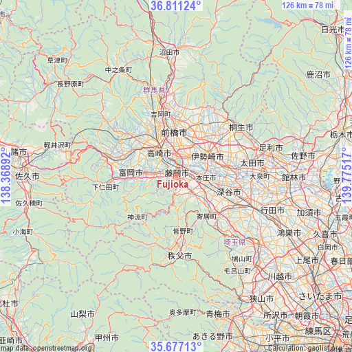
Fujioka GPS coordinates[2]
36° 14' 46.464" North, 139° 4' 19.344" East
| Map corner | latitude | longitude |
|---|---|---|
| Upper-left | 36.81124°, | 138.36892° |
| Center: | 36.24624°, | 139.07204° |
| Lower-right: | 35.67713°, | 139.77517° |
| Map W x H: | 126.1×126.1 km | = 78.4×78.4mi |
| max Lat: | 45.40944° ⇑27.7% North |
| Fujioka: | 36.24624° |
| min Lat: | ⇓72.3% South 24.34478° |
| min Long | Fujioka | max Long |
| 123° | 139.07204° | 145.575° |
| W 61.5%⇐ | ⇒38.5% E |
Elevation
Elevation of Fujioka is 94 m = 308 ft, and this is 9.4 m = 31 ft above average elevation for this country.
| Max E: |
1086 m = 3563 ft | 25.1% |
| Fujioka | 94 m 308 ft | |
| Avg. | 84.6 m = 278 ft | |
Min E: |
-2 m = -7 ft | 74.9% |
See also: Fujioka elevation on elevation.city.
Geographical zone
Fujioka is located in North temperate zone (between Tropic of Cancer and the Arctic Circle). Distance of this Northern Tropic circle is 1424.3 km =885 mi to South.| Distance of | km | miles | from Fujioka |
|---|---|---|---|
| North Pole | 5976.9 | 3713.9 | to North |
| Arctic Circle | 3371 | 2094.6 | to North |
| Tropic Cancer | 1424.3 | 885 | to South |
| Equator | 4030.2 | 2504.2 | to South |


Nearby cities:
15 places around Fujioka: (largest is in red/bold)
• Annaka
18.3 km =11.4 mi,  300°
300°
• Fukaya
18.6 km =11.6 mi,  114°
114°
• Fukayachō
19.6 km =12.2 mi, 105°
• Honjō
10.6 km =6.6 mi,  95°
95°
• Isesaki
13.9 km =8.6 mi,  55°
55°
• Kanekomachi
19.5 km =12.1 mi,  339°
339°
• Kodamachō-kodamaminami
8.7 km =5.4 mi,  141°
141°
• Maebashi
17.1 km =10.6 mi,  3°
3°
• Sakai-nakajima
16.1 km =10 mi,  81°
81°
• Takasaki
10.9 km =6.8 mi,  332°
332°
• Tamamura
7.2 km =4.5 mi,  33°
33°
• Tomioka
15.6 km =9.7 mi,  273°
273°
• Yorii
18.2 km =11.3 mi, 142°
• Yoshii
8 km =5 mi, 273°
• Ōta
27.1 km =16.8 mi, 77°
Sources, notices
• [Note1] Compared only with cities in Japan existing in our database
• [Src1] Map data: © OpenStreetMap contributors (CC-BY-SA)
• [Src2] Other city data from geonames.org with taken over terms of usage.
• [Src3] Geographical zone / Annual Mean Temperature by Robert A. Rohde @ Wikipedia
