Tamamura geodata
Tamamura (Gunma) is a populated place; located in Japan in Asia/Tokyo (GMT+9) time zone. With population of 42,566 people, there are 427 cities with bigger population in this country. Compared to other cities in Japan, 73.4% of cities are located further ↓South; 62.1% of cities are located further ←West and 69.1% of cities have lower elevation than Tamamura. Note1


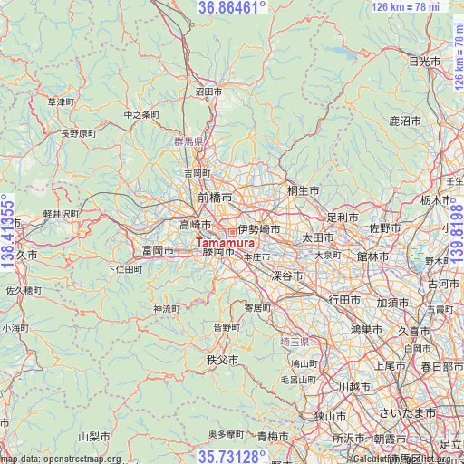
Tamamura GPS coordinates[2]
36° 18' 0" North, 139° 7' 0.012" East
| Map corner | latitude | longitude |
|---|---|---|
| Upper-left | 36.86461°, | 138.41355° |
| Center: | 36.3°, | 139.11667° |
| Lower-right: | 35.73128°, | 139.8198° |
| Map W x H: | 126×126 km | = 78.3×78.3mi |
| max Lat: | 45.40944° ⇑26.6% North |
| Tamamura: | 36.3° |
| min Lat: | ⇓73.4% South 24.34478° |
| min Long | Tamamura | max Long |
| 123° | 139.11667° | 145.575° |
| W 62.1%⇐ | ⇒37.9% E |
Elevation
Elevation of Tamamura is 68 m = 223 ft, and this is 16.6 m = 54 ft below average elevation for this country.
| Max E: |
1086 m = 3563 ft | 30.9% |
| Avg. | 84.6 m = 278 ft | |
| Tamamura | 68 m = 223 ft | |
Min E: |
-2 m = -7 ft | 69.1% |
See also: Tamamura elevation on elevation.city.
Geographical zone
Tamamura is located in North temperate zone (between Tropic of Cancer and the Arctic Circle). Distance of this Northern Tropic circle is 1430.3 km =888.7 mi to South.| Distance of | km | miles | from Tamamura |
|---|---|---|---|
| North Pole | 5970.9 | 3710.1 | to North |
| Arctic Circle | 3365 | 2090.9 | to North |
| Tropic Cancer | 1430.3 | 888.7 | to South |
| Equator | 4036.2 | 2508 | to South |


Nearby cities:
15 places around Tamamura: (largest is in red/bold)
• Annaka
20.1 km =12.5 mi,  279°
279°
• Fujioka
7.2 km =4.5 mi,  213°
213°
• Fukaya
18.8 km =11.7 mi,  136°
136°
• Fukayachō
18.6 km =11.6 mi,  126°
126°
• Honjō
9.6 km =6 mi, 136°
• Isesaki
7.7 km =4.8 mi,  76°
76°
• Kanekomachi
16.4 km =10.2 mi,  318°
318°
• Kodamachō-kodamaminami
12.9 km =8 mi,  173°
173°
• Maebashi
11.5 km =7.1 mi,  344°
344°
• Sakai-nakajima
12.5 km =7.8 mi,  107°
107°
• Takasaki
9.7 km =6 mi,  292°
292°
• Tomioka
20.2 km =12.6 mi,  255°
255°
• Yorii
21.6 km =13.4 mi,  161°
161°
• Yoshii
13.2 km =8.2 mi,  245°
245°
• Ōmamachō-ōmama
20.4 km =12.7 mi,  44°
44°
Sources, notices
• [Note1] Compared only with cities in Japan existing in our database
• [Src1] Map data: © OpenStreetMap contributors (CC-BY-SA)
• [Src2] Other city data from geonames.org with taken over terms of usage.
• [Src3] Geographical zone / Annual Mean Temperature by Robert A. Rohde @ Wikipedia
