Shido geodata
Shido (Kagawa) is a populated place; located in Japan in Asia/Tokyo (GMT+9) time zone. With population of 22,859 people, there are 644 cities with bigger population in this country. Compared to other cities in Japan, 75.6% of cities are located further ↑North; 74.2% of cities are located further →East and 86% of cities have higher elevation than Shido. Note1


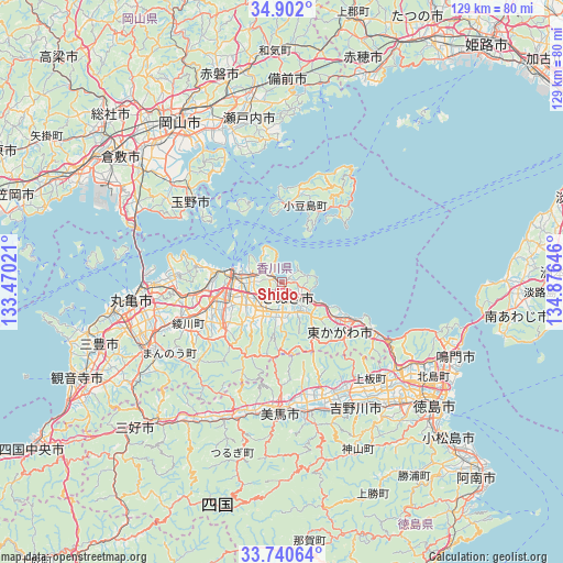
Shido GPS coordinates[2]
34° 19' 23.988" North, 134° 10' 23.988" East
| Map corner | latitude | longitude |
|---|---|---|
| Upper-left | 34.902°, | 133.47021° |
| Center: | 34.32333°, | 134.17333° |
| Lower-right: | 33.74064°, | 134.87646° |
| Map W x H: | 129.1×129.1 km | = 80.2×80.2mi |
| max Lat: | 45.40944° ⇑75.6% North |
| Shido: | 34.32333° |
| min Lat: | ⇓24.4% South 24.34478° |
| min Long | Shido | max Long |
| 123° | 134.17333° | 145.575° |
| W 25.8%⇐ | ⇒74.2% E |
Elevation
Elevation of Shido is 6 m = 20 ft, and this is 78.6 m = 258 ft below average elevation for this country.
| Max E: |
1086 m = 3563 ft | 86% |
| Avg. | 84.6 m = 278 ft | |
| Shido | 6 m = 20 ft | |
Min E: |
-2 m = -7 ft | 14% |
See also: Japan elevation on elevation.city.
Geographical zone
Shido is located in North temperate zone (between Tropic of Cancer and the Arctic Circle). Distance of this Northern Tropic circle is 1210.5 km =752.2 mi to South.| Distance of | km | miles | from Shido |
|---|---|---|---|
| North Pole | 6190.7 | 3846.7 | to North |
| Arctic Circle | 3584.8 | 2227.5 | to North |
| Tropic Cancer | 1210.5 | 752.2 | to South |
| Equator | 3816.4 | 2371.4 | to South |


Nearby cities:
15 places around Shido: (largest is in red/bold)
• Awa
27.7 km =17.2 mi,  158°
158°
• Higashikagawa
19.6 km =12.2 mi,  129°
129°
• Ishii
37.7 km =23.4 mi,  139°
139°
• Kamojimachō-jōgejima
32.7 km =20.3 mi,  150°
150°
• Marugame
36.1 km =22.4 mi,  262°
262°
• Mima
30 km =18.6 mi,  185°
185°
• Sakaidechō
31 km =19.3 mi,  269°
269°
• Sanuki
8.1 km =5 mi, 140°
• Setouchi
37.5 km =23.3 mi,  355°
355°
• Takamatsu
11.4 km =7.1 mi,  275°
275°
• Tamano
30 km =18.6 mi,  315°
315°
• Tonoshō
17.5 km =10.9 mi, 359°
• Wakimachi
28.6 km =17.8 mi,  184°
184°
• Yoshinogawa
33.5 km =20.8 mi, 160°
• Zentsujichó
37.9 km =23.5 mi,  253°
253°
Sources, notices
• [Note1] Compared only with cities in Japan existing in our database
• [Src1] Map data: © OpenStreetMap contributors (CC-BY-SA)
• [Src2] Other city data from geonames.org with taken over terms of usage.
• [Src3] Geographical zone / Annual Mean Temperature by Robert A. Rohde @ Wikipedia
