Sanuki geodata
Sanuki (Kagawa) is a seat of a second-order administrative division; located in Japan in Asia/Tokyo (GMT+9) time zone. In our database, there are 767 cities with bigger population. Compared to other cities in Japan, 76.5% of cities are located further ↑North; 74% of cities are located further →East and 54.9% of cities have lower elevation than Sanuki. Note1


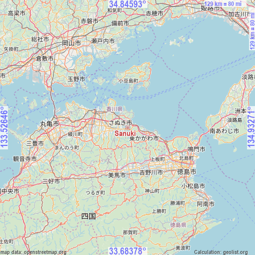
Sanuki GPS coordinates[2]
34° 16' 0.696" North, 134° 13' 46.488" East
| Map corner | latitude | longitude |
|---|---|---|
| Upper-left | 34.84593°, | 133.52646° |
| Center: | 34.26686°, | 134.22958° |
| Lower-right: | 33.68378°, | 134.93271° |
| Map W x H: | 129.2×129.2 km | = 80.3×80.3mi |
| max Lat: | 45.40944° ⇑76.5% North |
| Sanuki: | 34.26686° |
| min Lat: | ⇓23.5% South 24.34478° |
| min Long | Sanuki | max Long |
| 123° | 134.22958° | 145.575° |
| W 26%⇐ | ⇒74% E |
Elevation
Elevation of Sanuki is 35 m = 115 ft, and this is 49.6 m = 163 ft below average elevation for this country.
| Max E: |
1086 m = 3563 ft | 45.1% |
| Avg. | 84.6 m = 278 ft | |
| Sanuki | 35 m = 115 ft | |
Min E: |
-2 m = -7 ft | 54.9% |
See also: Japan elevation on elevation.city.
Geographical zone
Sanuki is located in North temperate zone (between Tropic of Cancer and the Arctic Circle). Distance of this Northern Tropic circle is 1204.2 km =748.3 mi to South.| Distance of | km | miles | from Sanuki |
|---|---|---|---|
| North Pole | 6196.9 | 3850.6 | to North |
| Arctic Circle | 3591.1 | 2231.4 | to North |
| Tropic Cancer | 1204.2 | 748.3 | to South |
| Equator | 3810.1 | 2367.5 | to South |


Nearby cities:
15 places around Sanuki: (largest is in red/bold)
• Awa
20.1 km =12.5 mi,  165°
165°
• Higashikagawa
11.7 km =7.3 mi,  122°
122°
• Ishii
29.6 km =18.4 mi,  138°
138°
• Kamojimachō-jōgejima
24.7 km =15.3 mi,  153°
153°
• Marugame
41 km =25.5 mi,  272°
272°
• Mima
25 km =15.5 mi,  199°
199°
• Narutochō-mitsuishi
35.7 km =22.2 mi,  102°
102°
• Sakaidechō
36.7 km =22.8 mi,  279°
279°
• Shido
8.1 km =5 mi,  320°
320°
• Takamatsu
18.1 km =11.2 mi,  294°
294°
• Tamano
38.1 km =23.7 mi, 316°
• Tokushima
38.2 km =23.7 mi,  125°
125°
• Tonoshō
24.4 km =15.2 mi,  347°
347°
• Wakimachi
23.4 km =14.5 mi, 198°
• Yoshinogawa
26 km =16.2 mi, 167°
Sources, notices
• [Note1] Compared only with cities in Japan existing in our database
• [Src1] Map data: © OpenStreetMap contributors (CC-BY-SA)
• [Src2] Other city data from geonames.org with taken over terms of usage.
• [Src3] Geographical zone / Annual Mean Temperature by Robert A. Rohde @ Wikipedia
