Takaungu geodata
Takaungu (Kilifi) is a populated place; located in Kenya in Africa/Nairobi (GMT+3) time zone. With population of 10,760 people, there are 64 cities with bigger population in this country. Compared to other cities in Kenya, 93.9% of cities are located further ↑North; 93.9% of cities are located further ←West and 94.7% of cities have higher elevation than Takaungu. Note1


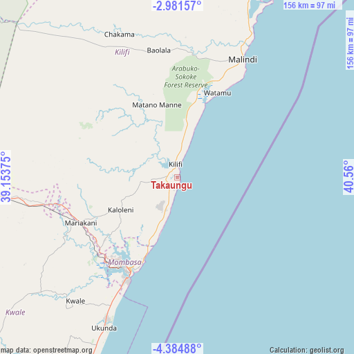
Takaungu GPS coordinates[2]
3° 41' 0.6" South, 39° 51' 24.732" East
| Map corner | latitude | longitude |
|---|---|---|
| Upper-left | -2.98157°, | 39.15375° |
| Center: | -3.6835°, | 39.85687° |
| Lower-right: | -4.38488°, | 40.56° |
| Map W x H: | 156×156 km | = 96.9×96.9mi |
| max Lat: | 3.93726° ⇑93.9% North |
| Takaungu: | -3.6835° |
| min Lat: | ⇓6.1% South -4.64756° |
| min Long | Takaungu | max Long |
| 33.97248° | 39.85687° | 41.85688° |
| W 93.9%⇐ | ⇒6.1% E |
Elevation
Elevation of Takaungu is 16 m = 52 ft, and this is 1330.7 m = 4366 ft below average elevation for this country.
| Max E: |
2514 m = 8248 ft | 94.7% |
| Avg. | 1346.7 m = 4418 ft | |
| Takaungu | 16 m = 52 ft | |
Min E: |
7 m = 23 ft | 5.3% |
See also: Kenya elevation on elevation.city.
Geographical zone
Takaungu is located in South Torrid zone (between Equator and Tropic of Capricorn). Distance of Equator is 409.6 km =254.5 mi to North.| Distance of | km | miles | from Takaungu |
|---|---|---|---|
| Equator | 409.6 | 254.5 | to North |
| Tropic Capricorn | 2196.4 | 1364.8 | to South |
| Antarctic Circle | 6991.6 | 4344.4 | to South |
| South Pole | 9597.5 | 5963.6 | to South |


Nearby cities:
15 places around Takaungu: (largest is in red/bold)
• Gazi
91.1 km =56.6 mi,  205°
205°
• Kilifi
5.9 km =3.7 mi,  352°
352°
• Kinango
78.5 km =48.8 mi,  229°
229°
• Kipini
148.6 km =92.3 mi,  29°
29°
• Kwale
70.6 km =43.9 mi,  219°
219°
• Lamu
195.2 km =121.3 mi,  36°
36°
• Malindi
59.3 km =36.8 mi, 29°
• Mariakani
46.9 km =29.1 mi,  244°
244°
• Mombasa
46.5 km =28.9 mi, 207°
• Mwatate
165.4 km =102.8 mi,  276°
276°
• Sawa Sawa
96.9 km =60.2 mi, 205°
• Shimoni
119.4 km =74.2 mi, 206°
• Voi
147.9 km =91.9 mi, 282°
• Witu
157.8 km =98.1 mi,  24°
24°
• Wundanyi
169.5 km =105.3 mi, 280°
Sources, notices
• [Note1] Compared only with cities in Kenya existing in our database
• [Src1] Map data: © OpenStreetMap contributors (CC-BY-SA)
• [Src2] Other city data from geonames.org with taken over terms of usage.
• [Src3] Geographical zone / Annual Mean Temperature by Robert A. Rohde @ Wikipedia
