Voi geodata
Voi (Taita Taveta) is a populated place; located in Kenya in Africa/Nairobi (GMT+3) time zone. With population of 45,483 people, there are 19 cities with bigger population in this country. Compared to other cities in Kenya, 89.5% of cities are located further ↑North; 84.2% of cities are located further ←West and 84.2% of cities have higher elevation than Voi. Note1


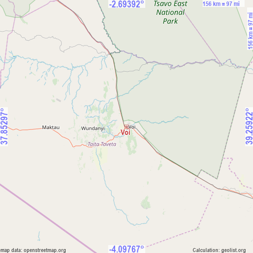
Voi GPS coordinates[2]
3° 23' 45.78" South, 38° 33' 21.924" East
| Map corner | latitude | longitude |
|---|---|---|
| Upper-left | -2.69392°, | 37.85297° |
| Center: | -3.39605°, | 38.55609° |
| Lower-right: | -4.09767°, | 39.25922° |
| Map W x H: | 156.1×156.1 km | = 97×97mi |
| max Lat: | 3.93726° ⇑89.5% North |
| Voi: | -3.39605° |
| min Lat: | ⇓10.5% South -4.64756° |
| min Long | Voi | max Long |
| 33.97248° | 38.55609° | 41.85688° |
| W 84.2%⇐ | ⇒15.8% E |
Elevation
Elevation of Voi is 580 m = 1903 ft, and this is 766.7 m = 2515 ft below average elevation for this country.
| Max E: |
2514 m = 8248 ft | 84.2% |
| Avg. | 1346.7 m = 4418 ft | |
| Voi | 580 m = 1903 ft | |
Min E: |
7 m = 23 ft | 15.8% |
See also: Voi elevation on elevation.city.
Geographical zone
Voi is located in South Torrid zone (between Equator and Tropic of Capricorn). Distance of Equator is 377.6 km =234.6 mi to North.| Distance of | km | miles | from Voi |
|---|---|---|---|
| Equator | 377.6 | 234.6 | to North |
| Tropic Capricorn | 2228.3 | 1384.6 | to South |
| Antarctic Circle | 7023.6 | 4364.3 | to South |
| South Pole | 9629.5 | 5983.5 | to South |


Nearby cities:
15 places around Voi: (largest is in red/bold)
• Gazi
155.5 km =96.6 mi,  137°
137°
• Kilifi
145.9 km =90.7 mi,  100°
100°
• Kinango
117.8 km =73.2 mi,  134°
134°
• Kwale
131.8 km =81.9 mi, 131°
• Makueni Boma
205.1 km =127.4 mi,  329°
329°
• Malindi
174.4 km =108.4 mi,  83°
83°
• Mariakani
114.4 km =71.1 mi,  116°
116°
• Mombasa
143 km =88.9 mi, 120°
• Mtito Andei
89.6 km =55.7 mi, 331°
• Mwatate
23.3 km =14.5 mi,  238°
238°
• Sawa Sawa
157.8 km =98.1 mi, 139°
• Shimoni
166.6 km =103.5 mi,  146°
146°
• Takaungu
147.9 km =91.9 mi, 102°
• Taveta
96.9 km =60.2 mi,  269°
269°
• Wundanyi
22.1 km =13.7 mi, 269°
Sources, notices
• [Note1] Compared only with cities in Kenya existing in our database
• [Src1] Map data: © OpenStreetMap contributors (CC-BY-SA)
• [Src2] Other city data from geonames.org with taken over terms of usage.
• [Src3] Geographical zone / Annual Mean Temperature by Robert A. Rohde @ Wikipedia
