Gazi geodata
Gazi (Kwale) is a populated place; located in Kenya in Africa/Nairobi (GMT+3) time zone. With population of 5,222 people, there are 84 cities with bigger population in this country. Compared to other cities in Kenya, 98.2% of cities are located further ↑North; 90.4% of cities are located further ←West and 96.5% of cities have higher elevation than Gazi. Note1


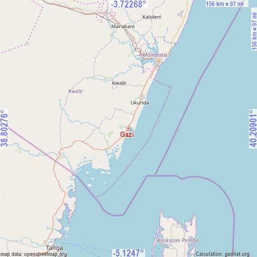
Gazi GPS coordinates[2]
4° 25' 26.472" South, 39° 30' 21.168" East
| Map corner | latitude | longitude |
|---|---|---|
| Upper-left | -3.72268°, | 38.80276° |
| Center: | -4.42402°, | 39.50588° |
| Lower-right: | -5.1247°, | 40.20901° |
| Map W x H: | 155.9×155.9 km | = 96.9×96.9mi |
| max Lat: | 3.93726° ⇑98.2% North |
| Gazi: | -4.42402° |
| min Lat: | ⇓1.8% South -4.64756° |
| min Long | Gazi | max Long |
| 33.97248° | 39.50588° | 41.85688° |
| W 90.4%⇐ | ⇒9.6% E |
Elevation
Elevation of Gazi is 15 m = 49 ft, and this is 1331.7 m = 4369 ft below average elevation for this country.
| Max E: |
2514 m = 8248 ft | 96.5% |
| Avg. | 1346.7 m = 4418 ft | |
| Gazi | 15 m = 49 ft | |
Min E: |
7 m = 23 ft | 3.5% |
See also: Kenya elevation on elevation.city.
Geographical zone
Gazi is located in South Torrid zone (between Equator and Tropic of Capricorn). Distance of Equator is 491.9 km =305.7 mi to North.| Distance of | km | miles | from Gazi |
|---|---|---|---|
| Equator | 491.9 | 305.7 | to North |
| Tropic Capricorn | 2114 | 1313.6 | to South |
| Antarctic Circle | 6909.3 | 4293.2 | to South |
| South Pole | 9515.2 | 5912.5 | to South |


Nearby cities:
15 places around Gazi: (largest is in red/bold)
• Kilifi
96.1 km =59.7 mi,  23°
23°
• Kinango
38.3 km =23.8 mi,  326°
326°
• Kipini
239.5 km =148.8 mi,  28°
28°
• Kwale
28.5 km =17.7 mi,  347°
347°
• Malindi
150.3 km =93.4 mi, 26°
• Mariakani
62.5 km =38.8 mi,  356°
356°
• Mombasa
44.6 km =27.7 mi, 23°
• Mtito Andei
243.4 km =151.2 mi,  322°
322°
• Mwatate
161.6 km =100.4 mi,  309°
309°
• Sawa Sawa
5.8 km =3.6 mi,  203°
203°
• Shimoni
28.4 km =17.6 mi,  208°
208°
• Takaungu
91.1 km =56.6 mi, 25°
• Taveta
232.1 km =144.2 mi,  299°
299°
• Voi
155.5 km =96.6 mi, 317°
• Wundanyi
171.1 km =106.3 mi, 311°
Sources, notices
• [Note1] Compared only with cities in Kenya existing in our database
• [Src1] Map data: © OpenStreetMap contributors (CC-BY-SA)
• [Src2] Other city data from geonames.org with taken over terms of usage.
• [Src3] Geographical zone / Annual Mean Temperature by Robert A. Rohde @ Wikipedia
