Mombasa geodata
Mombasa is a seat of a first-order administrative division; located in Kenya in Africa/Nairobi (GMT+3) time zone. With population of 799,668 people, there is 1 city with bigger population in this country. Compared to other cities in Kenya, 95.6% of cities are located further ↑North; 92.1% of cities are located further ←West and 93% of cities have higher elevation than Mombasa. Note1


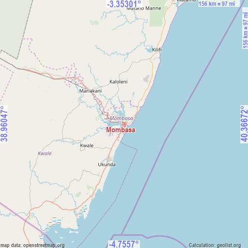
Mombasa GPS coordinates[2]
4° 3' 16.776" South, 39° 39' 48.924" East
| Map corner | latitude | longitude |
|---|---|---|
| Upper-left | -3.35301°, | 38.96047° |
| Center: | -4.05466°, | 39.66359° |
| Lower-right: | -4.7557°, | 40.36672° |
| Map W x H: | 156×156 km | = 96.9×96.9mi |
| max Lat: | 3.93726° ⇑95.6% North |
| Mombasa: | -4.05466° |
| min Lat: | ⇓4.4% South -4.64756° |
| min Long | Mombasa | max Long |
| 33.97248° | 39.66359° | 41.85688° |
| W 92.1%⇐ | ⇒7.9% E |
Elevation
Elevation of Mombasa is 20 m = 66 ft, and this is 1326.7 m = 4353 ft below average elevation for this country.
| Max E: |
2514 m = 8248 ft | 93% |
| Avg. | 1346.7 m = 4418 ft | |
| Mombasa | 20 m = 66 ft | |
Min E: |
7 m = 23 ft | 7% |
See also: Mombasa elevation on elevation.city.
Geographical zone
Mombasa is located in South Torrid zone (between Equator and Tropic of Capricorn). Distance of Equator is 450.8 km =280.1 mi to North.| Distance of | km | miles | from Mombasa |
|---|---|---|---|
| Equator | 450.8 | 280.1 | to North |
| Tropic Capricorn | 2155.1 | 1339.1 | to South |
| Antarctic Circle | 6950.3 | 4318.7 | to South |
| South Pole | 9556.2 | 5937.9 | to South |


Nearby cities:
15 places around Mombasa: (largest is in red/bold)
• Gazi
44.6 km =27.7 mi,  203°
203°
• Kilifi
51.5 km =32 mi,  23°
23°
• Kinango
39.7 km =24.7 mi,  256°
256°
• Kipini
195.1 km =121.2 mi,  29°
29°
• Kwale
26.9 km =16.7 mi,  240°
240°
• Malindi
105.8 km =65.7 mi, 28°
• Mariakani
29.9 km =18.6 mi,  315°
315°
• Mtito Andei
225 km =139.8 mi,  312°
312°
• Mwatate
155.3 km =96.5 mi,  293°
293°
• Sawa Sawa
50.4 km =31.3 mi, 203°
• Shimoni
73 km =45.4 mi,  205°
205°
• Takaungu
46.5 km =28.9 mi, 27°
• Voi
143 km =88.9 mi,  300°
300°
• Witu
204.2 km =126.9 mi, 24°
• Wundanyi
162.4 km =100.9 mi, 296°
Sources, notices
• [Note1] Compared only with cities in Kenya existing in our database
• [Src1] Map data: © OpenStreetMap contributors (CC-BY-SA)
• [Src2] Other city data from geonames.org with taken over terms of usage.
• [Src3] Geographical zone / Annual Mean Temperature by Robert A. Rohde @ Wikipedia
