Lamu geodata
Lamu is a seat of a first-order administrative division; located in Kenya in Africa/Nairobi (GMT+3) time zone. With population of 24,525 people, there are 40 cities with bigger population in this country. Compared to other cities in Kenya, 85.1% of cities are located further ↑North; 99.1% of cities are located further ←West and 97.4% of cities have higher elevation than Lamu. Note1


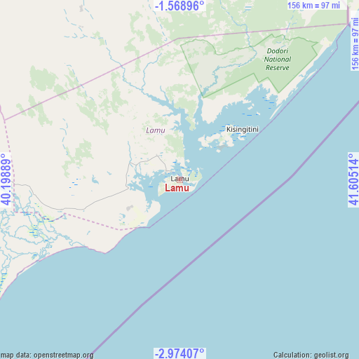
Lamu GPS coordinates[2]
2° 16' 18.084" South, 40° 54' 7.236" East
| Map corner | latitude | longitude |
|---|---|---|
| Upper-left | -1.56896°, | 40.19889° |
| Center: | -2.27169°, | 40.90201° |
| Lower-right: | -2.97407°, | 41.60514° |
| Map W x H: | 156.2×156.2 km | = 97.1×97.1mi |
| max Lat: | 3.93726° ⇑85.1% North |
| Lamu: | -2.27169° |
| min Lat: | ⇓14.9% South -4.64756° |
| min Long | Lamu | max Long |
| 33.97248° | 40.90201° | 41.85688° |
| W 99.1%⇐ | ⇒0.90000000000001% E |
Elevation
Elevation of Lamu is 14 m = 46 ft, and this is 1332.7 m = 4372 ft below average elevation for this country.
| Max E: |
2514 m = 8248 ft | 97.4% |
| Avg. | 1346.7 m = 4418 ft | |
| Lamu | 14 m = 46 ft | |
Min E: |
7 m = 23 ft | 2.6% |
See also: Kenya elevation on elevation.city.
Geographical zone
Lamu is located in South Torrid zone (between Equator and Tropic of Capricorn). Distance of Equator is 252.6 km =157 mi to North.| Distance of | km | miles | from Lamu |
|---|---|---|---|
| Equator | 252.6 | 157 | to North |
| Tropic Capricorn | 2353.3 | 1462.3 | to South |
| Antarctic Circle | 7148.6 | 4441.9 | to South |
| South Pole | 9754.5 | 6061.2 | to South |


Nearby cities:
15 places around Lamu: (largest is in red/bold)
• Garissa
245.8 km =152.7 mi,  325°
325°
• Gazi
285.1 km =177.2 mi,  212°
212°
• Hola
130.4 km =81 mi,  312°
312°
• Kilifi
191 km =118.7 mi,  217°
217°
• Kinango
272.1 km =169.1 mi, 220°
• Kipini
50.4 km =31.3 mi,  235°
235°
• Kwale
265.8 km =165.2 mi, 217°
• Malindi
136.7 km =84.9 mi, 219°
• Mariakani
237.5 km =147.6 mi, 221°
• Mombasa
241.3 km =149.9 mi, 214°
• Mtito Andei
307.4 km =191 mi,  261°
261°
• Sawa Sawa
290.8 km =180.7 mi, 212°
• Takaungu
195.2 km =121.3 mi, 216°
• Voi
289 km =179.6 mi, 244°
• Witu
53.1 km =33 mi, 255°
Sources, notices
• [Note1] Compared only with cities in Kenya existing in our database
• [Src1] Map data: © OpenStreetMap contributors (CC-BY-SA)
• [Src2] Other city data from geonames.org with taken over terms of usage.
• [Src3] Geographical zone / Annual Mean Temperature by Robert A. Rohde @ Wikipedia
