Kwale geodata
Kwale is a seat of a first-order administrative division; located in Kenya in Africa/Nairobi (GMT+3) time zone. With population of 4,883 people, there are 85 cities with bigger population in this country. Compared to other cities in Kenya, 97.4% of cities are located further ↑North; 87.7% of cities are located further ←West and 86% of cities have higher elevation than Kwale. Note1


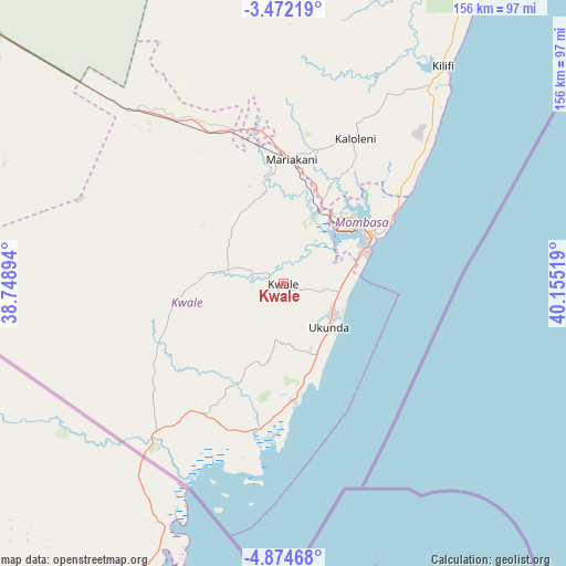
Kwale GPS coordinates[2]
4° 10' 25.5" South, 39° 27' 7.416" East
| Map corner | latitude | longitude |
|---|---|---|
| Upper-left | -3.47219°, | 38.74894° |
| Center: | -4.17375°, | 39.45206° |
| Lower-right: | -4.87468°, | 40.15519° |
| Map W x H: | 155.9×155.9 km | = 96.9×96.9mi |
| max Lat: | 3.93726° ⇑97.4% North |
| Kwale: | -4.17375° |
| min Lat: | ⇓2.6% South -4.64756° |
| min Long | Kwale | max Long |
| 33.97248° | 39.45206° | 41.85688° |
| W 87.7%⇐ | ⇒12.3% E |
Elevation
Elevation of Kwale is 403 m = 1322 ft, and this is 943.7 m = 3096 ft below average elevation for this country.
| Max E: |
2514 m = 8248 ft | 86% |
| Avg. | 1346.7 m = 4418 ft | |
| Kwale | 403 m = 1322 ft | |
Min E: |
7 m = 23 ft | 14% |
See also: Kenya elevation on elevation.city.
Geographical zone
Kwale is located in South Torrid zone (between Equator and Tropic of Capricorn). Distance of Equator is 464.1 km =288.4 mi to North.| Distance of | km | miles | from Kwale |
|---|---|---|---|
| Equator | 464.1 | 288.4 | to North |
| Tropic Capricorn | 2141.8 | 1330.9 | to South |
| Antarctic Circle | 6937.1 | 4310.5 | to South |
| South Pole | 9543 | 5929.7 | to South |


Nearby cities:
15 places around Kwale: (largest is in red/bold)
• Gazi
28.5 km =17.7 mi,  167°
167°
• Kilifi
74.8 km =46.5 mi,  36°
36°
• Kinango
15.7 km =9.8 mi,  284°
284°
• Kipini
218.6 km =135.8 mi,  33°
33°
• Malindi
129.4 km =80.4 mi, 34°
• Mariakani
34.7 km =21.6 mi,  4°
4°
• Mombasa
26.9 km =16.7 mi,  60°
60°
• Mtito Andei
218.1 km =135.5 mi,  319°
319°
• Mwatate
140.5 km =87.3 mi,  301°
301°
• Sawa Sawa
33.3 km =20.7 mi, 173°
• Shimoni
53.3 km =33.1 mi,  188°
188°
• Takaungu
70.6 km =43.9 mi, 39°
• Taveta
214.3 km =133.2 mi,  293°
293°
• Voi
131.8 km =81.9 mi,  311°
311°
• Wundanyi
149.1 km =92.6 mi, 305°
Sources, notices
• [Note1] Compared only with cities in Kenya existing in our database
• [Src1] Map data: © OpenStreetMap contributors (CC-BY-SA)
• [Src2] Other city data from geonames.org with taken over terms of usage.
• [Src3] Geographical zone / Annual Mean Temperature by Robert A. Rohde @ Wikipedia
