Mtito Andei geodata
Mtito Andei (Makueni) is a populated place; located in Kenya in Africa/Nairobi (GMT+3) time zone. With population of 4,763 people, there are 86 cities with bigger population in this country. Compared to other cities in Kenya, 87.7% of cities are located further ↑North; 81.6% of cities are located further ←West and 80.7% of cities have higher elevation than Mtito Andei. Note1


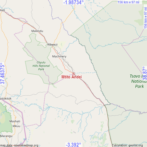
Mtito Andei GPS coordinates[2]
2° 41' 23.532" South, 38° 10' 0.732" East
| Map corner | latitude | longitude |
|---|---|---|
| Upper-left | -1.98734°, | 37.46375° |
| Center: | -2.68987°, | 38.16687° |
| Lower-right: | -3.392°, | 38.87° |
| Map W x H: | 156.2×156.2 km | = 97.1×97.1mi |
| max Lat: | 3.93726° ⇑87.7% North |
| Mtito Andei: | -2.68987° |
| min Lat: | ⇓12.3% South -4.64756° |
| min Long | Mtito Andei | max Long |
| 33.97248° | 38.16687° | 41.85688° |
| W 81.6%⇐ | ⇒18.4% E |
Elevation
Elevation of Mtito Andei is 754 m = 2474 ft, and this is 592.7 m = 1945 ft below average elevation for this country.
| Max E: |
2514 m = 8248 ft | 80.7% |
| Avg. | 1346.7 m = 4418 ft | |
| Mtito Andei | 754 m = 2474 ft | |
Min E: |
7 m = 23 ft | 19.3% |
See also: Kenya elevation on elevation.city.
Geographical zone
Mtito Andei is located in South Torrid zone (between Equator and Tropic of Capricorn). Distance of Equator is 299.1 km =185.9 mi to North.| Distance of | km | miles | from Mtito Andei |
|---|---|---|---|
| Equator | 299.1 | 185.9 | to North |
| Tropic Capricorn | 2306.8 | 1433.4 | to South |
| Antarctic Circle | 7102.1 | 4413 | to South |
| South Pole | 9708 | 6032.3 | to South |


Nearby cities:
15 places around Mtito Andei: (largest is in red/bold)
• Athi River
190.4 km =118.3 mi,  316°
316°
• Kajiado
180.3 km =112 mi,  301°
301°
• Kangundo
179 km =111.2 mi,  329°
329°
• Kinango
205.3 km =127.6 mi,  141°
141°
• Kitui
148.1 km =92 mi,  353°
353°
• Konza
156.2 km =97.1 mi,  312°
312°
• Machakos
164 km =101.9 mi, 322°
• Makueni Boma
115.5 km =71.8 mi, 328°
• Mariakani
195.1 km =121.2 mi,  131°
131°
• Mwatate
93.6 km =58.2 mi,  165°
165°
• Mwingi
195.4 km =121.4 mi,  356°
356°
• Taveta
95.4 km =59.3 mi,  214°
214°
• Voi
89.6 km =55.7 mi,  151°
151°
• Wote
117.4 km =72.9 mi, 329°
• Wundanyi
81.4 km =50.6 mi,  164°
164°
Sources, notices
• [Note1] Compared only with cities in Kenya existing in our database
• [Src1] Map data: © OpenStreetMap contributors (CC-BY-SA)
• [Src2] Other city data from geonames.org with taken over terms of usage.
• [Src3] Geographical zone / Annual Mean Temperature by Robert A. Rohde @ Wikipedia
