Uch-Korgon geodata
Uch-Korgon (Batken) is a seat of a third-order administrative division; located in Kyrgyzstan in Asia/Bishkek (GMT+6) time zone. In our database, there are 37 cities with bigger population. Compared to other cities in Kyrgyzstan, 69% of cities are located further ↑North; 60.7% of cities are located further →East and 61.9% of cities have higher elevation than Uch-Korgon. Note1


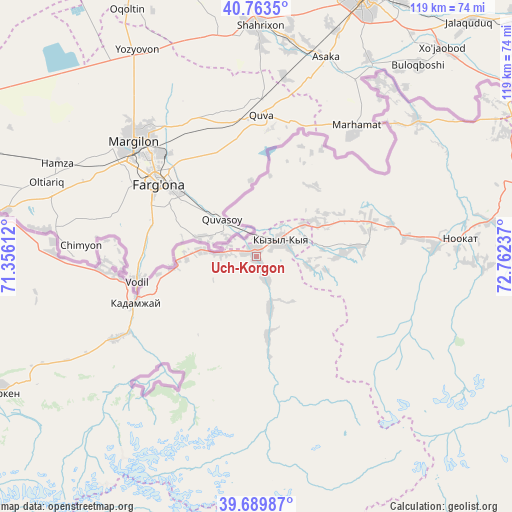
Uch-Korgon GPS coordinates[2]
40° 13' 43.716" North, 72° 3' 33.264" East
| Map corner | latitude | longitude |
|---|---|---|
| Upper-left | 40.7635°, | 71.35612° |
| Center: | 40.22881°, | 72.05924° |
| Lower-right: | 39.68987°, | 72.76237° |
| Map W x H: | 119.4×119.4 km | = 74.2×74.2mi |
| max Lat: | 42.89106° ⇑69% North |
| Uch-Korgon: | 40.22881° |
| min Lat: | ⇓31% South 39.55274° |
| min Long | Uch-Korgon | max Long |
| 69.3716° | 72.05924° | 78.52702° |
| W 39.3%⇐ | ⇒60.7% E |
Elevation
Elevation of Uch-Korgon is 971 m = 3186 ft, and this is 230.4 m = 756 ft below average elevation for this country.
| Max E: |
2638 m = 8655 ft | 61.9% |
| Avg. | 1201.4 m = 3942 ft | |
| Uch-Korgon | 971 m = 3186 ft | |
Min E: |
504 m = 1654 ft | 38.1% |
See also: Kyrgyzstan elevation on elevation.city.
Geographical zone
Uch-Korgon is located in North temperate zone (between Tropic of Cancer and the Arctic Circle). Distance of this Northern Tropic circle is 1867.1 km =1160.2 mi to South.| Distance of | km | miles | from Uch-Korgon |
|---|---|---|---|
| North Pole | 5534 | 3438.7 | to North |
| Arctic Circle | 2928.1 | 1819.4 | to North |
| Tropic Cancer | 1867.1 | 1160.2 | to South |
| Equator | 4473 | 2779.4 | to South |


Nearby cities:
15 places around Uch-Korgon: (largest is in red/bold)
• Alga
47.6 km =29.6 mi,  271°
271°
• Aravan
49.1 km =30.5 mi,  49°
49°
• Aydarken
68.8 km =42.8 mi,  242°
242°
• Iradan
5.4 km =3.4 mi,  39°
39°
• Kara-Dzhygach
12.2 km =7.6 mi,  166°
166°
• Kara-Dëbë
2.1 km =1.3 mi,  324°
324°
• Karavan
13.1 km =8.1 mi,  55°
55°
• Khalmion
36.3 km =22.6 mi, 267°
• Kyrgyz-Kyshtak
60.9 km =37.8 mi,  278°
278°
• Kyzyl-Bulak
33.7 km =20.9 mi,  234°
234°
• Kyzyl-Kyya
6.6 km =4.1 mi, 61°
• Markaz
13.6 km =8.5 mi, 275°
• Nookat
47.6 km =29.6 mi,  85°
85°
• Orozbekovo
38.3 km =23.8 mi, 240°
• Pulgon
29.4 km =18.3 mi,  252°
252°
Sources, notices
• [Note1] Compared only with cities in Kyrgyzstan existing in our database
• [Src1] Map data: © OpenStreetMap contributors (CC-BY-SA)
• [Src2] Other city data from geonames.org with taken over terms of usage.
• [Src3] Geographical zone / Annual Mean Temperature by Robert A. Rohde @ Wikipedia
