Pulgon geodata
Pulgon (Batken) is a seat of a second-order administrative division; located in Kyrgyzstan in Asia/Bishkek (GMT+6) time zone. In our database, there are 37 cities with bigger population. Compared to other cities in Kyrgyzstan, 72.6% of cities are located further ↑North; 67.9% of cities are located further →East and 60.7% of cities have higher elevation than Pulgon. Note1


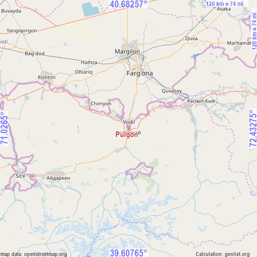
Pulgon GPS coordinates[2]
40° 8' 50.064" North, 71° 43' 46.632" East
| Map corner | latitude | longitude |
|---|---|---|
| Upper-left | 40.68257°, | 71.0265° |
| Center: | 40.14724°, | 71.72962° |
| Lower-right: | 39.60765°, | 72.43275° |
| Map W x H: | 119.5×119.5 km | = 74.3×74.3mi |
| max Lat: | 42.89106° ⇑72.6% North |
| Pulgon: | 40.14724° |
| min Lat: | ⇓27.4% South 39.55274° |
| min Long | Pulgon | max Long |
| 69.3716° | 71.72962° | 78.52702° |
| W 32.1%⇐ | ⇒67.9% E |
Elevation
Elevation of Pulgon is 982 m = 3222 ft, and this is 219.4 m = 720 ft below average elevation for this country.
| Max E: |
2638 m = 8655 ft | 60.7% |
| Avg. | 1201.4 m = 3942 ft | |
| Pulgon | 982 m = 3222 ft | |
Min E: |
504 m = 1654 ft | 39.3% |
See also: Kyrgyzstan elevation on elevation.city.
Geographical zone
Pulgon is located in North temperate zone (between Tropic of Cancer and the Arctic Circle). Distance of this Northern Tropic circle is 1858 km =1154.5 mi to South.| Distance of | km | miles | from Pulgon |
|---|---|---|---|
| North Pole | 5543.1 | 3444.3 | to North |
| Arctic Circle | 2937.2 | 1825.1 | to North |
| Tropic Cancer | 1858 | 1154.5 | to South |
| Equator | 4464 | 2773.8 | to South |


Nearby cities:
15 places around Pulgon: (largest is in red/bold)
• Alga
21.9 km =13.6 mi,  296°
296°
• Aydarken
40.1 km =24.9 mi,  235°
235°
• Boz-Adyr
58.2 km =36.2 mi,  253°
253°
• Iradan
34.1 km =21.2 mi,  67°
67°
• Kara-Dzhygach
31 km =19.3 mi,  95°
95°
• Kara-Dëbë
28.9 km =18 mi, 68°
• Karavan
42.1 km =26.2 mi, 67°
• Khalmion
10.9 km =6.8 mi,  311°
311°
• Kyrgyz-Kyshtak
37 km =23 mi, 299°
• Kyzyl-Bulak
10.6 km =6.6 mi,  176°
176°
• Kyzyl-Kyya
36 km =22.4 mi, 70°
• Markaz
17.8 km =11.1 mi,  54°
54°
• Ormosh
45.8 km =28.5 mi, 240°
• Orozbekovo
11.3 km =7 mi,  206°
206°
• Uch-Korgon
29.4 km =18.3 mi, 72°
Sources, notices
• [Note1] Compared only with cities in Kyrgyzstan existing in our database
• [Src1] Map data: © OpenStreetMap contributors (CC-BY-SA)
• [Src2] Other city data from geonames.org with taken over terms of usage.
• [Src3] Geographical zone / Annual Mean Temperature by Robert A. Rohde @ Wikipedia
