Kuleaen geodata
Kuleaen (Preah Vihear) is a seat of a second-order administrative division; located in Cambodia in Asia/Phnom_Penh (GMT+7) time zone. In our database, there are 29 cities with bigger population. Compared to other cities in Cambodia, 93.9% of cities are located further ↓South; 51.5% of cities are located further ←West and 83.3% of cities have lower elevation than Kuleaen. Note1


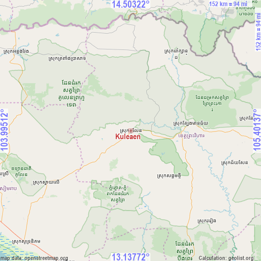
Kuleaen GPS coordinates[2]
13° 49' 17.292" North, 104° 41' 53.664" East
| Map corner | latitude | longitude |
|---|---|---|
| Upper-left | 14.50322°, | 103.99512° |
| Center: | 13.82147°, | 104.69824° |
| Lower-right: | 13.13772°, | 105.40137° |
| Map W x H: | 151.8×151.8 km | = 94.3×94.3mi |
| max Lat: | 14.23223° ⇑6.1% North |
| Kuleaen: | 13.82147° |
| min Lat: | ⇓93.9% South 10.48291° |
| min Long | Kuleaen | max Long |
| 102.37574° | 104.69824° | 107.42393° |
| W 51.5%⇐ | ⇒48.5% E |
Elevation
Elevation of Kuleaen is 75 m = 246 ft, and this is 23 m = 75 ft above average elevation for this country.
| Max E: |
678 m = 2224 ft | 16.7% |
| Kuleaen | 75 m 246 ft | |
| Avg. | 52 m = 171 ft | |
Min E: |
4 m = 13 ft | 83.3% |
See also: Cambodia elevation on elevation.city.
Geographical zone
Kuleaen is located in North Torrid zone (between Equator and Tropic of Cancer). Distance of this Northern Tropic circle is 1069.1 km =664.3 mi to North.| Distance of | km | miles | from Kuleaen |
|---|---|---|---|
| North Pole | 8470.3 | 5263.2 | to North |
| Arctic Circle | 5864.4 | 3644 | to North |
| Tropic Cancer | 1069.1 | 664.3 | to North |
| Equator | 1536.8 | 954.9 | to South |


Nearby cities:
15 places around Kuleaen: (largest is in red/bold)
• Angkor Chum
114.5 km =71.1 mi,  262°
262°
• Angkor Thum
96.7 km =60.1 mi,  247°
247°
• Anlong Veaeng
80.7 km =50.1 mi,  304°
304°
• Bakong
93.2 km =57.9 mi,  235°
235°
• Chi Kraeng
86.6 km =53.8 mi,  206°
206°
• Kampong Thom
125.2 km =77.8 mi,  170°
170°
• Pal Hal
30.4 km =18.9 mi,  96°
96°
• Sandan
99.8 km =62 mi,  142°
142°
• Sangkom Thmei
35.4 km =22 mi, 138°
• Siem Reap
104 km =64.6 mi, 240°
• Soutr Nikom
88.7 km =55.1 mi,  223°
223°
• Stoung
98.9 km =61.5 mi,  188°
188°
• Tbeng Meanchey
30.5 km =19 mi,  92°
92°
• Trapeang Prasat
54.9 km =34.1 mi,  317°
317°
• Varin
101.3 km =62.9 mi,  268°
268°
Sources, notices
• [Note1] Compared only with cities in Cambodia existing in our database
• [Src1] Map data: © OpenStreetMap contributors (CC-BY-SA)
• [Src2] Other city data from geonames.org with taken over terms of usage.
• [Src3] Geographical zone / Annual Mean Temperature by Robert A. Rohde @ Wikipedia
