Tbeng Meanchey geodata
Tbeng Meanchey (Preah Vihear) is a seat of a first-order administrative division; located in Cambodia in Asia/Phnom_Penh (GMT+7) time zone. With population of 24,380 people, there are 17 cities with bigger population in this country. Compared to other cities in Cambodia, 93.2% of cities are located further ↓South; 66.7% of cities are located further ←West and 78.8% of cities have lower elevation than Tbeng Meanchey. Note1


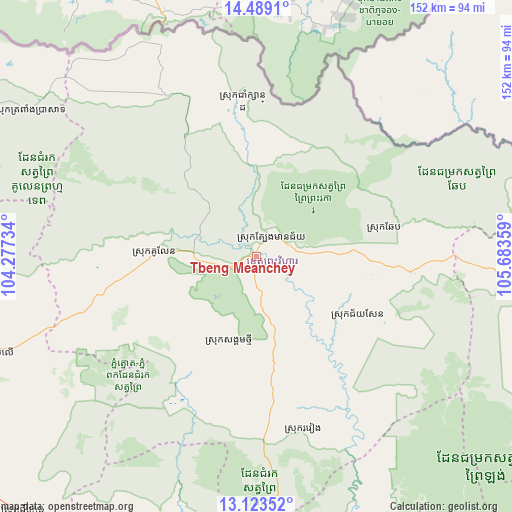
Tbeng Meanchey GPS coordinates[2]
13° 48' 26.316" North, 104° 58' 49.656" East
| Map corner | latitude | longitude |
|---|---|---|
| Upper-left | 14.4891°, | 104.27734° |
| Center: | 13.80731°, | 104.98046° |
| Lower-right: | 13.12352°, | 105.68359° |
| Map W x H: | 151.8×151.8 km | = 94.3×94.3mi |
| max Lat: | 14.23223° ⇑6.8% North |
| Tbeng Meanchey: | 13.80731° |
| min Lat: | ⇓93.2% South 10.48291° |
| min Long | Tbeng Meanchey | max Long |
| 102.37574° | 104.98046° | 107.42393° |
| W 66.7%⇐ | ⇒33.3% E |
Elevation
Elevation of Tbeng Meanchey is 59 m = 194 ft, and this is 7 m = 23 ft above average elevation for this country.
| Max E: |
678 m = 2224 ft | 21.2% |
| Tbeng Meanchey | 59 m 194 ft | |
| Avg. | 52 m = 171 ft | |
Min E: |
4 m = 13 ft | 78.8% |
See also: Cambodia elevation on elevation.city.
Geographical zone
Tbeng Meanchey is located in North Torrid zone (between Equator and Tropic of Cancer). Distance of this Northern Tropic circle is 1070.7 km =665.3 mi to North.| Distance of | km | miles | from Tbeng Meanchey |
|---|---|---|---|
| North Pole | 8471.8 | 5264.1 | to North |
| Arctic Circle | 5865.9 | 3644.9 | to North |
| Tropic Cancer | 1070.7 | 665.3 | to North |
| Equator | 1535.2 | 953.9 | to South |


Nearby cities:
15 places around Tbeng Meanchey: (largest is in red/bold)
• Angkor Thum
124.8 km =77.5 mi,  253°
253°
• Anlong Veaeng
107.9 km =67 mi,  295°
295°
• Bakong
118.9 km =73.9 mi,  244°
244°
• Chi Kraeng
102.5 km =63.7 mi,  222°
222°
• Kampong Thom
122.3 km =76 mi,  184°
184°
• Kuleaen
30.5 km =19 mi,  272°
272°
• Pal Hal
1.7 km =1.1 mi,  186°
186°
• Sandan
83.5 km =51.9 mi,  159°
159°
• Sangkom Thmei
26.1 km =16.2 mi,  196°
196°
• Sesan
123.4 km =76.7 mi,  103°
103°
• Soutr Nikom
110.9 km =68.9 mi, 235°
• Stoung
106.1 km =65.9 mi, 204°
• Stueng Saen
122.3 km =76 mi, 184°
• Stung Treng
111.2 km =69.1 mi,  106°
106°
• Trapeang Prasat
79.6 km =49.5 mi, 302°
Sources, notices
• [Note1] Compared only with cities in Cambodia existing in our database
• [Src1] Map data: © OpenStreetMap contributors (CC-BY-SA)
• [Src2] Other city data from geonames.org with taken over terms of usage.
• [Src3] Geographical zone / Annual Mean Temperature by Robert A. Rohde @ Wikipedia
