Stung Treng geodata
Stung Treng is a seat of a first-order administrative division; located in Cambodia in Asia/Phnom_Penh (GMT+7) time zone. With population of 25,000 people, there are 16 cities with bigger population in this country. Compared to other cities in Cambodia, 78.8% of cities are located further ↓South; 87.1% of cities are located further ←West and 78% of cities have lower elevation than Stung Treng. Note1


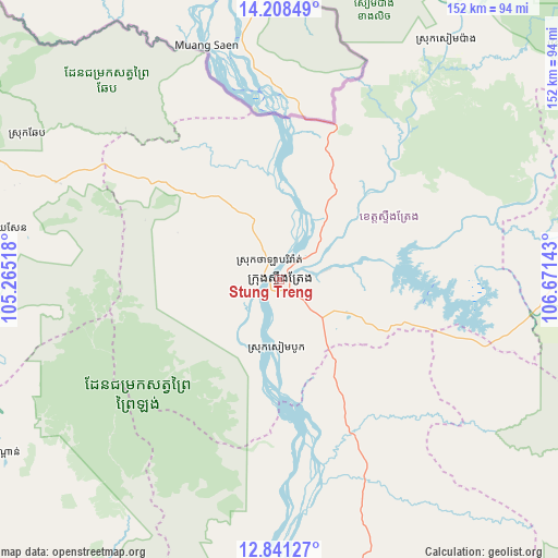
Stung Treng GPS coordinates[2]
13° 31' 33.096" North, 105° 58' 5.88" East
| Map corner | latitude | longitude |
|---|---|---|
| Upper-left | 14.20849°, | 105.26518° |
| Center: | 13.52586°, | 105.9683° |
| Lower-right: | 12.84127°, | 106.67143° |
| Map W x H: | 152×152 km | = 94.4×94.4mi |
| max Lat: | 14.23223° ⇑21.2% North |
| Stung Treng: | 13.52586° |
| min Lat: | ⇓78.8% South 10.48291° |
| min Long | Stung Treng | max Long |
| 102.37574° | 105.9683° | 107.42393° |
| W 87.1%⇐ | ⇒12.9% E |
Elevation
Elevation of Stung Treng is 55 m = 180 ft, and this is 3 m = 10 ft above average elevation for this country.
| Max E: |
678 m = 2224 ft | 22% |
| Stung Treng | 55 m 180 ft | |
| Avg. | 52 m = 171 ft | |
Min E: |
4 m = 13 ft | 78% |
See also: Cambodia elevation on elevation.city.
Geographical zone
Stung Treng is located in North Torrid zone (between Equator and Tropic of Cancer). Distance of this Northern Tropic circle is 1102 km =684.8 mi to North.| Distance of | km | miles | from Stung Treng |
|---|---|---|---|
| North Pole | 8503.1 | 5283.6 | to North |
| Arctic Circle | 5897.2 | 3664.3 | to North |
| Tropic Cancer | 1102 | 684.8 | to North |
| Equator | 1503.9 | 934.5 | to South |


Nearby cities:
15 places around Stung Treng: (largest is in red/bold)
• Banlung
112.6 km =70 mi,  77°
77°
• Bar Kaev
135.8 km =84.4 mi, 82°
• Koun Mom
87.2 km =54.2 mi,  86°
86°
• Kratié
115.5 km =71.8 mi,  177°
177°
• Kuleaen
141.1 km =87.7 mi,  283°
283°
• Lumphat
109.5 km =68 mi, 92°
• Ou Chum
114.8 km =71.3 mi,  74°
74°
• Pal Hal
111 km =69 mi,  285°
285°
• Preaek Prasab
130.5 km =81.1 mi, 176°
• Sandan
90.4 km =56.2 mi,  238°
238°
• Sangkom Thmei
114.2 km =71 mi,  273°
273°
• Sesan
13.7 km =8.5 mi, 77°
• Siem Pang
79.9 km =49.6 mi,  34°
34°
• Tbeng Meanchey
111.2 km =69.1 mi, 286°
• Veun Sai
103.9 km =64.6 mi,  61°
61°
Sources, notices
• [Note1] Compared only with cities in Cambodia existing in our database
• [Src1] Map data: © OpenStreetMap contributors (CC-BY-SA)
• [Src2] Other city data from geonames.org with taken over terms of usage.
• [Src3] Geographical zone / Annual Mean Temperature by Robert A. Rohde @ Wikipedia
