Banlung geodata
Banlung (Ratanakiri) is a seat of a first-order administrative division; located in Cambodia in Asia/Phnom_Penh (GMT+7) time zone. With population of 17,000 people, there are 26 cities with bigger population in this country. Compared to other cities in Cambodia, 88.6% of cities are located further ↓South; 95.5% of cities are located further ←West and 98.5% of cities have lower elevation than Banlung. Note1


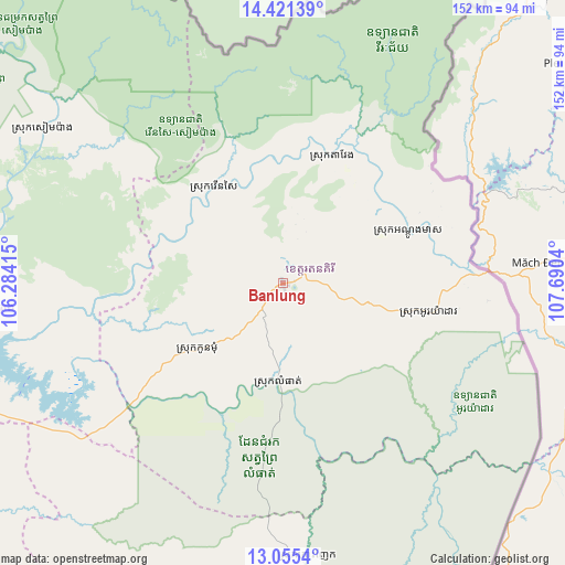
Banlung GPS coordinates[2]
13° 44' 21.804" North, 106° 59' 14.172" East
| Map corner | latitude | longitude |
|---|---|---|
| Upper-left | 14.42139°, | 106.28415° |
| Center: | 13.73939°, | 106.98727° |
| Lower-right: | 13.0554°, | 107.6904° |
| Map W x H: | 151.9×151.9 km | = 94.4×94.4mi |
| max Lat: | 14.23223° ⇑11.4% North |
| Banlung: | 13.73939° |
| min Lat: | ⇓88.6% South 10.48291° |
| min Long | Banlung | max Long |
| 102.37574° | 106.98727° | 107.42393° |
| W 95.5%⇐ | ⇒4.5% E |
Elevation
Elevation of Banlung is 316 m = 1037 ft, and this is 264 m = 866 ft above average elevation for this country.
| Max E: |
678 m = 2224 ft | 1.5% |
| Banlung | 316 m 1037 ft | |
| Avg. | 52 m = 171 ft | |
Min E: |
4 m = 13 ft | 98.5% |
See also: Cambodia elevation on elevation.city.
Geographical zone
Banlung is located in North Torrid zone (between Equator and Tropic of Cancer). Distance of this Northern Tropic circle is 1078.2 km =670 mi to North.| Distance of | km | miles | from Banlung |
|---|---|---|---|
| North Pole | 8479.4 | 5268.9 | to North |
| Arctic Circle | 5873.5 | 3649.6 | to North |
| Tropic Cancer | 1078.2 | 670 | to North |
| Equator | 1527.7 | 949.3 | to South |


Nearby cities:
15 places around Banlung: (largest is in red/bold)
• Andoung Meas
36.3 km =22.6 mi,  66°
66°
• Bar Kaev
25.2 km =15.7 mi,  103°
103°
• Kaev Seima
173 km =107.5 mi,  183°
183°
• Koun Mom
29.3 km =18.2 mi,  232°
232°
• Kratié
174.2 km =108.2 mi,  217°
217°
• Lumphat
27.6 km =17.1 mi, 181°
• Ou Chum
6.5 km =4 mi,  6°
6°
• Ou Ya Dav
39.6 km =24.6 mi, 101°
• Pechreada
140.2 km =87.1 mi,  160°
160°
• Preaek Prasab
185.4 km =115.2 mi,  213°
213°
• Sen Monorom
144.4 km =89.7 mi,  171°
171°
• Sesan
98.9 km =61.5 mi,  257°
257°
• Siem Pang
77.1 km =47.9 mi,  303°
303°
• Stung Treng
112.6 km =70 mi, 257°
• Veun Sai
32.4 km =20.1 mi,  324°
324°
Sources, notices
• [Note1] Compared only with cities in Cambodia existing in our database
• [Src1] Map data: © OpenStreetMap contributors (CC-BY-SA)
• [Src2] Other city data from geonames.org with taken over terms of usage.
• [Src3] Geographical zone / Annual Mean Temperature by Robert A. Rohde @ Wikipedia
